Jenison, Michigan
| Jenison, Michigan | |
|---|---|
| Unincorporated community & census-designated place | |
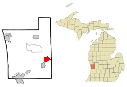
 Location of Jenison within Ottawa County, Michigan |
|
| Coordinates: 42°54′20″N 85°47′31″W / 42.90556°N 85.79194°WCoordinates: 42°54′20″N 85°47′31″W / 42.90556°N 85.79194°W | |
| Country | United States |
| State | Michigan |
| County | Ottawa |
| Settled | 1836 |
| Government | |
| • Township Supervisor | Dale Mohr |
| Area | |
| • Unincorporated community & census-designated place | 5.9 sq mi (15.3 km2) |
| • Land | 5.9 sq mi (15.2 km2) |
| • Water | 0.0 sq mi (0.1 km2) |
| Elevation | 604 ft (184 m) |
| Population (2010) | |
| • Unincorporated community & census-designated place | 16,538 |
| • Density | 2,803.1/sq mi (1,080.9/km2) |
| • Metro | 1,306,768 (Grand Rapids-Muskegon-Holland MSA) |
| Time zone | EST (UTC-5) |
| • Summer (DST) | EDT (UTC-4) |
| ZIP codes | 49428-49429 |
| Area code(s) | 616 |
| FIPS code | 26-41680 |
| GNIS feature ID | 0629253 |
Jenison is an unincorporated community in Ottawa County in the U.S. state of Michigan. It is a census-designated place (CDP) for statistical purposes, but has no legal status as an incorporated municipality. The community is governed by Georgetown Charter Township. The population of the CDP was 17,211 as of the 2000 census. The current estimated population for the entire Jenison ZIP code, 49428, is 25,770. The geographical boundaries of the ZIP code are larger than that of the CDP.
It is a bedroom community in proximity to Grand Rapids.
A post office called Jenisonville was established in 1872, and the name was changed to Jenison in 1887. The Jenison family opened a mill there in 1864.
According to the United States Census Bureau, the community has a total area of 5.9 square miles (15 km2), of which 5.8 square miles (15 km2) is land and 0.1 square miles (0.26 km2) (0.85%) is water.
As of the census of 2000, there were 17,211 people, 5,975 households, and 4,863 families residing in the community. The population density was 2,940.8 per square mile (1,135.9/km²). There were 6,065 housing units at an average density of 1,036.3 per square mile (400.3/km²). The racial makeup of the community was 98.84% White, 0.49% African American, 0.21% Native American, 0.85% Asian, 0.01% Pacific Islander, 0.53% from other races, and 0.87% from two or more races. Hispanic or Latino of any race were 1.77% of the population.
...
Wikipedia
