Jefferson, Greene County, Pennsylvania
| Jefferson, Greene County, Pennsylvania |
|
|---|---|
| Borough | |

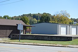
Site of the former Monongahela College on Pennsylvania Route 188
|
|
| Etymology: Thomas Jefferson | |
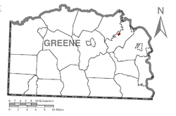
 Location of Jefferson in Greene County |
|
| Location of Jefferson in Greene County | |
| Coordinates: 39°55′49″N 80°3′32″W / 39.93028°N 80.05889°WCoordinates: 39°55′49″N 80°3′32″W / 39.93028°N 80.05889°W | |
| Country | United States |
| State | Pennsylvania |
| County | Greene |
| Established | 1795 |
| Government | |
| • Mayor | Dennis Crile |
| Area | |
| • Total | 0.19 sq mi (0.49 km2) |
| • Land | 0.19 sq mi (0.49 km2) |
| • Water | 0.0 sq mi (0.0 km2) |
| Elevation | 960 ft (290 m) |
| Population (2010) | |
| • Total | 270 |
| • Density | 1,437/sq mi (554.8/km2) |
| Time zone | EST (UTC-4) |
| • Summer (DST) | EDT (UTC-5) |
| Area code(s) | 724 |
| FIPS code | 42-37880 |
Jefferson is a borough in Greene County, Pennsylvania, United States. The population was 270 at the 2010 census, down from 337 at the 2000 census. The borough was named after Thomas Jefferson.
Jefferson is located in northeastern Greene County at 39°55′49″N 80°3′32″W / 39.93028°N 80.05889°W (39.930322, -80.058993). It is surrounded by Jefferson Township, a separate municipality. Pennsylvania Route 188 (Jefferson Road) passes through the center of the borough, leading east 3 miles (5 km) to Dry Tavern and west 7 miles (11 km) to Waynesburg, the county seat.
According to the United States Census Bureau, the borough has a total area of 0.19 square miles (0.49 km2), all of it land. The South Fork of Tenmile Creek passes just north of the borough.
As of the census of 2000, there were 337 people, 139 households, and 97 families residing in the borough. The population density was 1,801.8 people per square mile (684.8/km²). There were 147 housing units at an average density of 786.0/sq mi (298.7/km²). The racial makeup of the borough was 99.41% White, 0.30% African American, and 0.30% from two or more races.
...
Wikipedia


