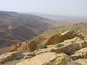
Jebel Gharbi
| Nafusa Mountains | |
|---|---|
| جبال نفوسة | |
 |
|
| Highest point | |
| Elevation | 968 m (3,176 ft) |
| Coordinates | 31°51′54″N 11°47′36″E / 31.8649°N 11.7933°ECoordinates: 31°51′54″N 11°47′36″E / 31.8649°N 11.7933°E |
| Geography | |
| Location | Tripolitania, northwest Libya |
The Nafusa Mountains (Berber: Adrar n Infusen (Nafusa Mountain), Arabic: [جبل نفوسة (Western mountain)) are a mountain range in the western Tripolitania region of northwestern Libya. It also includes their regions around the escarpment formed where the northern end of the Tripolitanian Plateau meets the Mediterranean coastal plain or the Jefara.
The area was as a major population and cultural center of the Libu, who repeatedly expanded west.
The Nafusa Mountains shelters most of Libya's Berber-speaking population, who speak Nafusi Berber.
In the aftermath of the great Berber Revolt of the 8th century, Ibadi missionaries that had fled from the Umayyad Caliphate took refuge in the Nafusa Mountains. Preachers converted and organized the native Nafusa people into a fighting force. Under the leadership of Imam Abu al-Khattab al-Ma'afari, the Nafusa descended from the mountains and proceeded to conquer all of the crumbling Fihrid emirate of Ifriqiya - capturing Tripoli in 757 and Kairouan in 758. But the Abbasid Arab governor of Egypt invaded Ifriqya, defeated the Nafusa in a battle at Tawergha in 761 (his third attempt - his first two armies had been repulsed) and put an end to their putative new state. However, the Nafusa mountains themselves remained unconquered. Throughout the 9th century, while the Aghlabids ruled in Ifriqiya, the Ibadi maintained an independent puritan republic in the Nafusa mountains. The Imamate of Nafusa was in close alliance with the other Ibadi remnant, the Rustamid dynasty in Tiaret, both constant thorns on either side of the Aghlabids, in communication with each other across the back highlands of North Africa.
...
Wikipedia

