Jean Lafitte, Louisiana
| Jean Lafitte, Louisiana | |
| Town | |
|
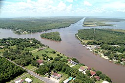
A portion of Jean Lafitte, Louisiana, along the Gulf Intracoastal Waterway and Bayou Barataria
|
|
| Country | United States |
|---|---|
| State | Louisiana |
| Parish | Jefferson |
| Elevation | 3 ft (0.9 m) |
| Coordinates | 29°44′10″N 90°07′36″W / 29.73611°N 90.12667°WCoordinates: 29°44′10″N 90°07′36″W / 29.73611°N 90.12667°W |
| Area | 6.3 sq mi (16.3 km2) |
| - land | 6.0 sq mi (16 km2) |
| - water | 0.3 sq mi (1 km2), 4.76% |
| Population | 1,903 (2010) |
| Density | 324.7/sq mi (125.4/km2) |
| Mayor | Timothy P. Kerner (D) |
| Timezone | CST (UTC-6) |
| - summer (DST) | CDT (UTC-5) |
| Area code | 504 |
|
Website: www |
|
Jean Lafitte is a town on Bayou Barataria in Jefferson Parish, Louisiana, United States. It is named after the privateer Jean Lafitte. The population was 1,903 at the 2010 census. It is part of the New Orleans–Metairie–Kenner Metropolitan Statistical Area.
Jean Lafitte is located at 29°44′10″N 90°07′36″W / 29.73611°N 90.12667°W (29.735587, -90.122053).
According to the United States Census Bureau, the town has a total area of 6.3 square miles (16 km2), of which, 6.0 square miles (16 km2) of it is land and 0.3 square miles (0.78 km2) of it (4.47%) is water.
In 2012, a historical marker for the community of Manila Village was placed in Jean Lafitte. Since mid-2013, Manila Plaza, designed attractively and located in front of Jean Lafitte Town Hall, has held several historical markers and commemorative plaques acknowledging important individuals in the area's Filipino American history. The Philippine-Louisiana Historical Society participated in the dedication ceremony.
...
Wikipedia


