Jasper, Florida
| Jasper, Florida | |
|---|---|
| City | |

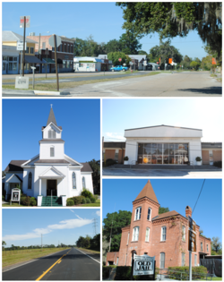
Images top, left to right: Downtown Jasper, First United Methodist Church, Hamilton County Courthouse, U.S. Route 129, Old Hamilton County Jail
|
|
 Location in Hamilton County and the state of Florida |
|
| Coordinates: 30°31′8″N 82°57′4″W / 30.51889°N 82.95111°WCoordinates: 30°31′8″N 82°57′4″W / 30.51889°N 82.95111°W | |
| Country |
|
| State |
|
| County | Hamilton |
| Area | |
| • Total | 2 sq mi (5.1 km2) |
| • Land | 2 sq mi (5.1 km2) |
| • Water | 0 sq mi (0 km2) |
| Elevation | 151 ft (46 m) |
| Population (2010) | |
| • Total | 4,546 |
| • Density | 890/sq mi (349/km2) |
| Time zone | Eastern (EST) (UTC-5) |
| • Summer (DST) | EDT (UTC-4) |
| ZIP code | 32052 |
| Area code(s) | 386 |
| FIPS code | 12-35375 |
| GNIS feature ID | 0284730 |
| Website | http://jasperflonline.com/ |
Jasper is a city in Hamilton County, Florida, United States. The population was 4,546 at the 2010 census. It is the county seat of Hamilton County. The Old Hamilton County Jail and the United Methodist Church in Jasper are on the National Register of Historic Places. One of the largest industries is phosphate mining.
Jasper is located at 30°31′08″N 82°57′04″W / 30.518856°N 82.951194°W.
Set in the North Florida lowlands 83 miles west of Jacksonville, 90 miles east of Tallahassee, 35 miles south of Valdosta, Georgia, 32 miles north of Lake City, the town is situated close to supplies but far enough away to retain some independence and solitude. Jasper is topically located on a slightly higher elevated area surrounded by lowland, it is believed to rest on land originally thought to be the site of Miccosukee (Mikasukis) Indians, a sub tribe of the Seminole nation. The 1823 Treaty of Moultrie bought the Indian lands and the population was required to move southeast of the Suwannee River. This allowed settlers to move into the area. A suspected Indian burial mound is located at Baisden (named after Josiah Baisden) Swamp just on the outskirts of Jasper. Six miles north of Jasper along the Alapaha River an established Indian village called Halata-Micco (Hala-at-a-Mico) (named for Chief Billy Bowlegs of the Seminole, who may have resided there) once stood, Chief Bowlegs signed the Treaty of Paynes Landing (1832) as Hola-at-a-Mico, his x mark (aka Billy Bowlegs) establishing the type of Indian inhabiting the area where artifacts of pottery, fishing spear points, and arrowheads are often found.
Soon after the Treaty of Moultrie in 1823 was delivered, Hamilton County was established as part of the original 15 counties in Florida, allowed settlers which came mostly from Georgia and South Carolina to move into the area in earnest between 1827 through the 1840s. In 1840 inhabitants of our town were calling the settlement Pulaski; others called it Wall. Records tell us that Daniel Bell, living just outside the settlement in 1824, was County Judge in 1828, appointed under the authority of the Acting Territorial Governor McCarty in Tallahassee. In 1839 he was a member of the Territorial Legislative Council. Legend has it that Mr. Bell, also considered to be the first settler of the county, disagreed with developing names for the little township and he met with locals (one of them named Simon Whitehurst, one of the few Revolutionary War veterans in Florida, buried in Jasper) and other friends where they decided to submit the name of Jasper, in honor of Revolutionary War Veteran William Jasper, to the territorial capitol in Tallahassee. There the name was/is registered and incorporated as documented in the Territorial Legislative Journal. In 1841 the “Jasper Post Office” was established ending any discussion on names for the town. Florida became a state in 1845 and thirteen years later on March 2, 1858 it is believed that the town’s leaders thought they should finally “officially” incorporate the town of Jasper under statehood.
...
Wikipedia
