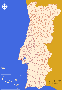
Jamor
| Oeiras | |||
|---|---|---|---|
| Municipality | |||

The manorhouse of the Marquess of Pombal Sebastião José de Carvalho e Melo
|
|||
|
|||
 |
|||
| Coordinates: 38°41′N 9°19′W / 38.683°N 9.317°WCoordinates: 38°41′N 9°19′W / 38.683°N 9.317°W | |||
| Country |
|
||
| Region | Lisbon | ||
| Subregion | Grande Lisboa | ||
| Metropolitan area | Lisbon | ||
| District | Lisbon | ||
| Parishes | 5 | ||
| Government | |||
| • President | Paulo Vistas (Independent) | ||
| Area | |||
| • Total | 45.88 km2 (17.71 sq mi) | ||
| Lowest elevation | 0 m (0 ft) | ||
| Population (2011) | |||
| • Total | 172,120 | ||
| • Density | 3,800/km2 (9,700/sq mi) | ||
| Time zone | WET/WEST (UTC+0/+1) | ||
| Postal code | 2784 | ||
| Area code | 214 | ||
| Patron | Nossa Senhora da Purificação | ||
| Website | www |
||
Oeiras (Portuguese pronunciation: [oˈɐjɾɐʃ]) is a municipality in western part of the Lisbon Metropolitan Area, subregion of Greater Lisbon, in continental Portugal. It is part of the urban agglomeration of Lisbon. The population in 2011 was 172,120, in an area of 45.88 km², making the municipality the fifth-most densely populated in Portugal.
Oeiras is an important economic hub, being one of the most highly developed municipalities of Portugal and Europe. It has the highest GDP (Growth Domestic Product) in the country, being also the second municipality (right after Lisbon) with the highest purchasing power as well as the second one collecting taxes in the country. This economic results are also a reflection of the inhabitants studies, being Oeiras the municipality with the highest concentration of population with higher education in the country and the lowest unemployment rate in the Lisbon area.
The mild climate, access to water, quality of its soils and geographically privileged location at the mouth of the Tagus River attracted early settlement to this region. The rugged hilltops of the interior conditioned cultivation and allowed the settlement of several small agricultural castros within the regions limits, such as Castro of Leceia (which was classified in 1963 as a property of public interest). This archaeological site is a witness to the early settlements and defensive structures that developed during the Calcolithic period, although Paleolithic camps, such as Gruta da Ponte da Laje suggest earlier settlements.
Remnants of the Roman occupation of the Iberian peninsula are evident in many places throughout the municipality, including mosaics, specifically along the Rua das Alcássimas, and a Roman bridge. The latter Arab conquest left behind several toponomic markers, such as Arab/Moorish place names: Alcássimas, Algés, Alpendroado and Quinta da Moura.
The settlement of Oeiras dates back to 1208, when the area was colonized by Christian tribes from the northern Portugal, moving south into warmer agricultural lands.
...
Wikipedia


