Jamestown, Kansas
| Jamestown, Kansas | |
|---|---|
| City | |

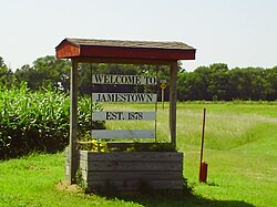
Welcome sign, north of town (2011)
|
|
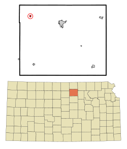
 Location within Cloud County and Kansas |
|
 KDOT map of Cloud County (legend) |
|
| Coordinates: 39°36′0″N 97°51′42″W / 39.60000°N 97.86167°WCoordinates: 39°36′0″N 97°51′42″W / 39.60000°N 97.86167°W | |
| Country | United States |
| State | Kansas |
| County | Cloud |
| Government | |
| • Type | Mayor–Council |
| Area | |
| • Total | 0.29 sq mi (0.75 km2) |
| • Land | 0.29 sq mi (0.75 km2) |
| • Water | 0 sq mi (0 km2) |
| Elevation | 1,434 ft (437 m) |
| Population (2010) | |
| • Total | 286 |
| • Estimate (2016) | 277 |
| • Density | 990/sq mi (380/km2) |
| Time zone | Central (CST) (UTC-6) |
| • Summer (DST) | CDT (UTC-5) |
| ZIP code | 66948 |
| Area code | 785 |
| FIPS code | 20-34975 |
| GNIS feature ID | 0473308 |
Jamestown is a city in Cloud County, Kansas, United States. As of the 2010 census, the city population was 286.
Jamestown was founded in 1878, and was incorporated as a city in 1883. It was named for either Senator James Pomeroy, or James P. Pomeroy, a railroad official. A post office was opened in Alva (an extinct town) in 1871, but it was moved to Jamestown in 1878. The town located itself on the Missouri Pacific Railroad.
In 1911 the entire downtown business district was destroyed by a fire. Few records remain of that fire, but the townspeople subsequently rebuilt the downtown commercial district.
History repeated itself on January 28, 2000 when another fire consumed several buildings on Main Street and spread to the city hall. And again, history repeated itself as the town rebuilt. Mayor Judy Hill stated, "A fire like that can destroy a small town, but instead it ignited a community spirit here." In a few days, Jamestown was having town meetings to make plans for the future.
The funeral home in Jamestown was selected as the temporary city office and meeting place. More than 50 people (out of a population of 307 at the time) came to town meetings there and the citizens organized into several committees to begin work.
Today, Jamestown has a new community center with daycare facilities and a thriving downtown activities center with a health clinic, public library, and several businesses.
Jamestown is located at 39°36′0″N 97°51′42″W / 39.60000°N 97.86167°W (39.600031, -97.861759). According to the United States Census Bureau, the city has a total area of 0.29 square miles (0.75 km2), all of it land.
As of the census of 2010, there were 286 people, 126 households, and 84 families residing in the city. The population density was 986.2 inhabitants per square mile (380.8/km2). There were 148 housing units at an average density of 510.3 per square mile (197.0/km2). The racial makeup of the city was 97.6% White, 0.7% African American, 0.7% Native American, 0.3% Asian, 0.3% from other races, and 0.3% from two or more races. Hispanic or Latino of any race were 0.7% of the population.
...
Wikipedia
