James River Bridge
| James River Bridge | |
|---|---|

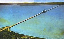
The 1928 bridge, replaced from 1975 to 1982
|
|
| Coordinates | 36°59′28″N 76°29′01″W / 36.9910°N 76.4836°WCoordinates: 36°59′28″N 76°29′01″W / 36.9910°N 76.4836°W |
| Carries | 4 lanes of |
| Crosses | James River |
| Locale | Isle of Wight County, VA to Newport News, VA |
| Maintained by | Virginia DOT |
| ID number | 10364 |
| Characteristics | |
| Design | steel lift bridge |
| Total length | 7.0714 km (4.3940 mi) |
| Width | 20.8 m (68.2 ft) |
| Longest span | 126.5 m (415.0 ft) |
| Clearance above | 4.87 m (16.0 ft) |
| Clearance below | 44.1 m (145 ft) open 18.2 m (59.7 ft) closed |
| History | |
| Opened | 1982 |
 |
|
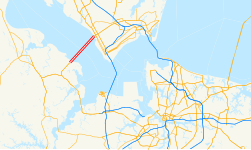
The James River Bridge is a four-lane divided highway lift bridge across the James River in the Commonwealth of Virginia. Owned and operated by the Virginia Department of Transportation, it carries U.S. Route 17 (US 17), US 258, and State Route 32 across the river near its mouth at Hampton Roads. The bridge connects Newport News on the Virginia Peninsula with Isle of Wight County in the South Hampton Roads region, and is the easternmost such crossing without a tunnel component.
When completed in 1928, the 4.5-mile (7 km) bridge was the longest bridge in the world over water. The original two-lane bridge was replaced from 1975 to 1982 with a wider four-lane bridge that could handle increased traffic volumes. In 2005, the bridge carried an annual average daily traffic of about 30,000 vehicles per day.
At the Newport News end, traffic approaches the bridge at a six-ramp partial cloverleaf interchange, where Mercury Boulevard (carrying U.S. Route 17, U.S. Route 258, and State Route 32 onto the bridge) passes over Warwick Boulevard (U.S. Route 60). After an intersection with River Road and the entrance to Huntington Park, the four-lane divided bridge begins, lying to the southeast a part of the old bridge that remains as a fishing pier. The 126.5 m (415.0 ft) lift span over the shipping channel, with a clearance of 44.1 m (145 ft) when raised and 18.2 m (59.7 ft) when lowered, is about 1/4 of the way along the 7.0714 km (4.3940 mi) bridge. This allows ocean-going ships to pass en route to civilian port facilities in Hopewell and at the Port of Richmond.
...
Wikipedia
