Jacquemart Island

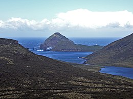
Jacquemart Island in the distance
|
|
| Geography | |
|---|---|
| Coordinates | 52°37′10″S 169°07′33″E / 52.61944°S 169.12583°E |
| Archipelago | Campbell Island group |
| Area | 19 ha (47 acres) |
| Length | 0.75 km (0.466 mi) |
| Width | 0.5 km (0.31 mi) |
| Highest elevation | 200.0 m (656.2 ft) |
| Administration | |
|
New Zealand
|
|
| Demographics | |
| Population | Uninhabited |
Jacquemart Island, one of the islets surrounding Campbell Island in New Zealand, lies 1 km (0.62 mi) south of Campbell Island and is the southernmost island of New Zealand.
While Jacquemart Island belongs indisputably to New Zealand, New Zealand also claims territory in Antarctica which stretches to the South Pole. Like other Antarctic territorial claims, New Zealand's jurisdiction over the Ross Dependency is not recognised by most nations. The name commemorates Captain J. Jacquemart, of the vessel FRWS Vire, that supported the French 1874 Transit of Venus Expedition to Campbell Island.
Coordinates: 52°37′10″S 169°07′33″E / 52.61944°S 169.12583°E
Jacquemart Island consists of a stack with an area of 19 ha (47 acres), being about 750 m (2,461 ft) in length by 500 metres (1,640 ft) in width and surrounded by precipitous cliffs at least 30 m (98 ft) high at their lowest. Its highest point is about 200 m (656 ft) asl. It is an eroded remnant of basaltic lavas originally laid down on a sedimentary base. Because of its inaccessibility from the sea, the first visit by humans to the island did not take place until 29 December 1980 when a small party of scientists was landed by helicopter on the summit ridge for a 90-minute survey. Subsequent short visits were made in 1984 and 1997.
...
Wikipedia
