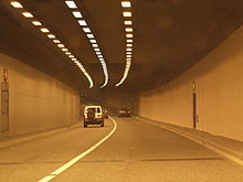
Jack Lynch Tunnel

The N40 through the interior of the southbound bore.
|
|
| Overview | |
|---|---|
| Location | Cork, crossing the River Lee |
| Route | N40 |
| Operation | |
| Work begun | 1995 |
| Opened | 1999 |
| Technical | |
| Length | 610 metres (670 yd) (immersed tube tunnel section) 1.8 kilometres (1.1 mi) (total roadway) |
| No. of lanes | 2 cells of 2 each |
| Operating speed | 80 km/h |
| Tunnel clearance | 8.5 metres (28 ft) (external) |
| Width | 24.5 metres (80.4 ft) (external) |
The Jack Lynch Tunnel (Irish: Tollán Sheáin Uí Loingsigh) is an immersed tube tunnel and an integral part of the N40 southern ring road of Cork in Ireland. It is named after former Taoiseach, Jack Lynch, a native of Cork.
It takes the road under the River Lee. North of the tunnel, the ring-road joins the M8 motorway to Dublin (north) and N8 road to the city centre (west), with the N25 commencing east to Waterford. The tunnel was completed in May 1999, and carried nearly 40,000 vehicles per day as of 2005. This number rose further as the N40 ring-road's upgrades progressed, with the opening of the Kinsale road roundabout flyover in 2006 and the recently completed upgrades to the Sarsfield Road and Bandon Road Roundabouts. Traffic in 2015 is 63,000 vehicles a day up from 59,000 in 2013.
The tunnel has two cells, each with two traffic lanes and two footpaths, and a central bore for use in an emergency only. Pedestrians and cyclists are expressly forbidden from using the tunnel. The exclusion of cyclists has been somewhat controversial as the feeder road is a dual-carriageway and so is open to cyclists, but the by-law is applied because of space limitations and the obvious danger of cyclists in an enclosed tunnel.
The idea of a crossing of the River Lee downstream of the city came from civil engineers employed by Cork Local Authorities and the central government's Department of the Environment in the late 1970s. Cork's suburbs were expanding and traffic was rising as car ownership increased, but the city centre's street plan, laid out in the late Middle Ages, was ill equipped to cope. The engineers reasoned that the congestion in the city centre and its radial routes was quickly reaching intolerable levels. They pushed through Cork's "LUTS" – Land Use and Transportation Study – plan, to lay down a twenty five-year plan for the orderly growth of transport and land use in the greater Cork area. The transportation proposals combined construction of elements of a ring road, a downstream crossing, and computerised management of traffic on existing roads. This group of engineers became the Technical Steering Committee for the LUTS Plan and at that time consisted of Sean McCarthy, the former City Engineer, W.A. "Liam" Fitzgerald, his successor as City Engineer, Liam Mullins, Cork's County Engineer, John O'Regan, his deputy, B.J. O'Sullivan, the Cork Harbour Engineer, and Sean Walsh and Declan O'Driscoll, the two Assistant Chief Engineering Advisers at the Department of the Environment responsible for the region. The location and type of crossing was not established by the LUTS plan.
...
Wikipedia
