Izu, Shizuoka
|
Izu 伊豆市 |
|||
|---|---|---|---|
| City | |||

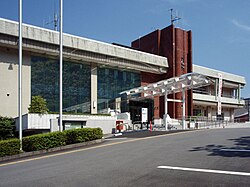
Izu City Hall
|
|||
|
|||
 Location of Izu in Shizuoka Prefecture |
|||
| Coordinates: 34°58′35.5″N 138°56′48.5″E / 34.976528°N 138.946806°ECoordinates: 34°58′35.5″N 138°56′48.5″E / 34.976528°N 138.946806°E | |||
| Country | Japan | ||
| Region | Chūbu (Tōkai) | ||
| Prefecture | Shizuoka Prefecture | ||
| Area | |||
| • Total | 363.97 km2 (140.53 sq mi) | ||
| Population (September 2015) | |||
| • Total | 31,265 | ||
| • Density | 85.9/km2 (222/sq mi) | ||
| Time zone | Japan Standard Time (UTC+9) | ||
| City symbols | |||
| • Tree | Quercus acutissima | ||
| • Flower | Wasabi | ||
| • Bird | Green pheasant | ||
| Phone number | 0558-72-1111 | ||
| Address | Kodachino 38-2, Izu-shi, Shizuoka-ken 410-2413 | ||
| Website | Official website | ||
Izu (伊豆市 Izu-shi?) is a city located in central Izu Peninsula in Shizuoka Prefecture, Japan.
As of September 2015, the city had an estimated population of 31,265 and a population density of 85.9 persons per km2. The total was 363.97 square kilometres (140.53 sq mi).
Izu is located in the north-central portion of Izu Peninsula, and includes most of the Amagi Mountains. The region is hilly and some 80% of the city area is covered by forest. The Kano River runs through the city, which has a short coastline to the west on Suruga Bay of the Pacific Ocean. The area has numerous hot springs. Warmed by the warm Kuroshio Current, the area enjoys a warm maritime climate with hot, humid summers and mild, cool winters.
During the Edo period, most of Izu Province was tenryō territory under direct control of the Tokugawa shogunate, although portions near modern Shuzenji were under the control of the Okubo clan of Ogino-Yamanaka Domain. During the cadastral reform of the early Meiji period in 1889, the area was reorganized into several villages under Kimisawa District, Shizuoka Prefecture. Kimisawa District merged with Tagata District in 1896.
...
Wikipedia


