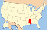
Itawamba County, Mississippi
| Itawamba County, Mississippi | |
|---|---|
 Location in the U.S. state of Mississippi |
|
 Mississippi's location in the U.S. |
|
| Founded | 1836 |
| Named for | Levi Colbert (Itawamba) |
| Seat | Fulton |
| Largest city | Fulton |
| Area | |
| • Total | 540 sq mi (1,399 km2) |
| • Land | 533 sq mi (1,380 km2) |
| • Water | 7.7 sq mi (20 km2), 1.4% |
| Population | |
| • (2010) | 23,401 |
| • Density | 44/sq mi (17/km²) |
| Congressional district | 1st |
| Time zone | Central: UTC-6/-5 |
Itawamba County is a county located in the U.S. state of Mississippi. As of the 2010 census, the population was 23,401. Its county seat is Fulton. The county was named for the Chickasaw leader Itawamba, known to English-speaking settlers as Levi Colbert. He was prominent during the Indian Removal period of the early 19th century, but died before his people left the area. The county was the site of the 2010 Itawamba County School District prom controversy when a lesbian student attempted to bring her partner to prom.
The county is part of the Tupelo, MS Micropolitan Statistical Area.
According to the U.S. Census Bureau, the county has a total area of 540 square miles (1,400 km2), of which 533 square miles (1,380 km2) is land and 7.7 square miles (20 km2) (1.4%) is water.
As of the census of 2000, there were 22,770 people, 8,773 households, and 6,500 families residing in the county. The population density was 43 people per square mile (17/km²). There were 9,804 housing units at an average density of 18 per square mile (7/km²). The racial makeup of the county was 92.47% White, 6.47% Black or African American, 0.14% Native American, 0.18% Asian, 0.32% from other races, and 0.42% from two or more races. 0.99% of the population were Hispanic or Latino of any race.
...
Wikipedia
