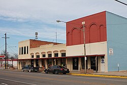
Itasca, Texas
| Itasca, Texas | |
|---|---|
| City | |
 |
|
| Motto: "The Big Little Town" | |
 Location of Itasca, Texas |
|
 |
|
| Coordinates: 32°9′31″N 97°8′52″W / 32.15861°N 97.14778°WCoordinates: 32°9′31″N 97°8′52″W / 32.15861°N 97.14778°W | |
| Country | United States |
| State | Texas |
| County | Hill |
| Area | |
| • Total | 1.2 sq mi (3.1 km2) |
| • Land | 1.2 sq mi (3.1 km2) |
| • Water | 0.0 sq mi (0.0 km2) |
| Elevation | 702 ft (214 m) |
| Population (2010) | |
| • Total | 1,644 |
| • Density | 1,242.9/sq mi (479.9/km2) |
| Time zone | Central (CST) (UTC-6) |
| • Summer (DST) | CDT (UTC-5) |
| ZIP code | 76055 |
| Area code(s) | 254 |
| FIPS code | 48-37084 |
| GNIS feature ID | 1338519 |
| Website | http://www.biglittletowntx.com/ |
Itasca /aɪˈtæskə/ eye-TAS-kə is a city in Hill County in Northern Central Texas. As of the 2010 census, the city population was 1,644.
Itasca began as a railroad station for the Missouri, Kansas and Texas Railroad in 1881, and was incorporated in 1885. City records show that between 2000-2008 more than 31,000 traffic tickets were issued.
Itasca is located at 32°9′31″N 97°8′52″W / 32.15861°N 97.14778°W (32.158509, -97.147852).
According to the United States Census Bureau, the city has a total area of 1.2 square miles (3.1 km2), all of it land. The town's theme seen on some of its signs and its website is the "Big Little Town." Located off I-35W south of Fort Worth, Texas, and north of Waco, Texas, Itasca is the approximate midway point between the two cites.
As of the census of 2000, there were 1,503 people, 549 households, and 384 families residing in the city. The population density was 1,242.9 people per square mile (479.6/km²). There were 612 housing units at an average density of 506.1 per square mile (195.3/km²). The racial makeup of the city was 64.54% White, 17.03% African American, 0.47% Native American, 0.07% Asian, 16.10% from other races, and 1.80% from two or more races. Hispanic or Latino of any race were 26.41% of the population.
...
Wikipedia
