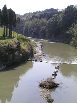
Isumi River
| Isumi River | |
|---|---|
 |
|
| Native name | 夷隅川 |
| Country | Japan |
| Basin | |
| Main source | Katsuura, Chiba Kamiueno District |
| River mouth |
Pacific Ocean 0 m (0 ft) 35°17′41″N 140°24′31″E / 35.29472°N 140.40861°ECoordinates: 35°17′41″N 140°24′31″E / 35.29472°N 140.40861°E |
| Basin size | 299 km2 (115 sq mi) |
| Physical characteristics | |
| Length | 68 km (42 mi) |
The Isumi River (夷隅川 Isumigawa?) is a river in Chiba Prefecture, Japan. It is 68 kilometers (42 mi) in length and has a drainage area of 299 square kilometers (115 sq mi). Under the Rivers Act of 1906 the Isumi is designated as a Class 2 River. Additionally, the government has designated the Isumi River a national-level Natural Monument (天然記念物 tennen kinenbutsu?).
The source of the Isumi River is in the Kamiueno District of Katsuura City. It meanders through Ōtaki and Isumi City and pours into the Pacific Ocean south of Cape Taitō in the Misakichoizumi District in the northeast of Isumi City. The riverbed consists primarily of shale and has few sandy areas.
Two species of oak are found on the upper parts of the river and Japanese cedar on the middle and lower parts of the river. The riverbanks of the Isumi are known for their dense bamboo thickets. Fish in the river include the endangered Tokyo bitterling, ayu, medaka, freshwater eel, Japanese dace, and other species of carp. Chiba Prefecture is carrying out some work on improving the environment of the Isumi River in Ōtaki area.
...
Wikipedia
