Issaquena County, MS
| Issaquena County, Mississippi | |
|---|---|
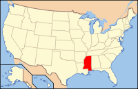
 Location in the U.S. state of Mississippi |
|
 Mississippi's location in the U.S. |
|
| Founded | 1844 |
| Seat | Mayersville |
| Largest town | Mayersville |
| Area | |
| • Total | 441 sq mi (1,142 km2) |
| • Land | 413 sq mi (1,070 km2) |
| • Water | 28 sq mi (73 km2), 6.4% |
| Population (est.) | |
| • (2015) | 1,337 |
| • Density | 3.4/sq mi (1/km²) |
| Congressional district | 2nd |
| Time zone | Central: UTC-6/-5 |
Issaquena County is a county located in the U.S. state of Mississippi. As of the 2010 census, the population was 1,406, making it the least populous county east of the Mississippi River. Its county seat is Mayersville.
Issaquena County is located in the Mississippi Delta region. The Mississippi River flows along the entire western boundary of the county, and many of the earliest communities were river ports.
The county's economy is chiefly based on agriculture, though a number of hunting camps are also located here and contribute to the economy. Mississippi's two most recent records for the heaviest alligator taken by a hunter have both been in Issaquena County, the latest in 2012 when a 697.5 lb (316.4 kg) alligator was taken at a camp near Fitler.
"Issaquena" is a Choctaw word meaning "Deer River". The Choctaw people were the first inhabitants of the county, and were removed from their land in 1820. Non-Native settlers began arriving in the early 1830s.
Issaquena county was established on January 23, 1844, from the southern portion of Washington County. The first county seat was located in Skipwith, and then moved to Duncansby (both communities are now ghost towns). In 1848, the county seat moved to Tallula, and in 1871, to Mayersville.
The county lies entirely in the Mississippi Alluvial Plain, and hardwood forest known as "bottomland" grows thick in the nutrient-rich, high-clay "buckshot" soil. Early settlers cleared many forests, and by the early 1890s about 50,000 acres (20,000 ha) of the county was growing corn, cotton, and oats. About that same time, the Louisville, New Orleans and Texas Railway was completed along a north-south route through the center of the county.
In 1876, Sharkey County was created from portions of Issaquena, Warren, and Washington counties.
...
Wikipedia
