Israel National Trail
| Israel National Trail | |
|---|---|

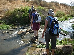
Hikers on the Israel National Trail
|
|
| Established | 1995 |
| Length | 1,025 kilometres (636.9 mi) |
| Location | Israel |
| Trailheads | North: Dan, South: Eilat |
| Use | Hiking |
| Hiking details | |
| Season | Early spring |
| Months | November to May |
| Website | http://www.israeltrail.net/ |
The Israel National Trail, (Hebrew: שביל ישראל, Shvil Yisra'el) is a hiking path that was inaugurated in 1995. The trail crosses the entire country of Israel. Its northern end is at Dan, near the Lebanese border in the far north of the country, and it extends to Eilat at the southernmost tip of Israel on the Red Sea, a length of 1,015 km (631 mi).
The trail is marked with three stripes (white, blue, and orange), and takes an average of 45-60 days to complete. It does not enter the Golan Heights or the West Bank.
The Israel National Trail has been listed in National Geographic's 20 most "epic trails." It is described as a trail that "delves into the grand scale of biblical landscapes as well as the everyday lives of the modern Israeli."
Since January 2016, the Israel National Trail can be explored on Google Street View. Israel National Trail on Google Street View.
The Israel National Trail (INT) is the brainchild of Avraham Tamir a journalist and hiker who hiked the Appalachian trail in the late 70's and Ori Dvir, hiker, educator and one of the founders of The Society for Protection of Nature in Israel (SPNI). The INT is over 1000 kilometers long and is marked, managed and maintained by The Israel Trails Committee which also blazes, marks and maintains the 15,000 kilometers of hiking trails all over Israel. The Israel National Trail was officially inaugurated by then President of Israel, Ezer Weizmann in 1994. One of its purposes is to give Israelis a way to experience the entire breadth of the land firsthand. The various sections of the trail have been added progressively during this development.
In 2003 a portion of the trail was diverted from the Sharon and now runs along the coast. The reasons for the change were the development of Highway 6, avoiding the security risk of walking along the Green Line and the desire to add to the trail sections with city and sea views.
...
Wikipedia
