Island of Ré

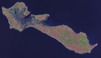
Satellite photo of Île de Ré
|
|
| Geography | |
|---|---|
| Location | Atlantic Ocean |
| Coordinates | 46°12′N 1°25′W / 46.200°N 1.417°WCoordinates: 46°12′N 1°25′W / 46.200°N 1.417°W |
| Area | 85 km2 (33 sq mi) |
| Length | 30 km (19 mi) |
| Width | 5 km (3.1 mi) |
| Highest elevation | 20 m (70 ft) |
| Highest point | Peu des Aumonts |
| Administration | |
|
France
|
|
| Region | Poitou-Charentes |
| Department | Charente-Maritime |
| Arrondissement | La Rochelle |
| Largest settlement | La Flotte |
| Demographics | |
| Population | 17,723 (2012) |
| Pop. density | 208.5 /km2 (540 /sq mi) |
| Ethnic groups | French people |
Île de Ré (pronounced: [il də ʁe]; variously spelled Rhé, Rhéa or Rhea; in English Isle of Rhé) is an island off the west coast of France near La Rochelle, on the northern side of the Pertuis d'Antioche strait. Its highest point has an elevation of 20 metres (66 feet). It is 30 kilometres (19 miles) long and 5 kilometres (3 miles) wide. The 2.9 km (1.8 mi) Île de Ré bridge, completed in 1988, connects it to La Rochelle on the mainland.
Administratively, the island is part of the Charente-Maritime département, in the Poitou-Charentes région. The island is also a part of the Charente-Maritime's 1st constituency.
Located in the arrondissement of La Rochelle, Île de Ré includes two cantons: Saint-Martin-de-Ré eastwards and Ars-en-Ré westwards. The island is divided into 10 communes, from East to West: Rivedoux-Plage, La Flotte, Sainte-Marie-de-Ré, Saint-Martin-de-Ré, Le Bois-Plage-en-Ré, La Couarde-sur-Mer, Loix, Ars-en-Ré, Saint-Clément-des-Baleines, Les Portes-en-Ré.
...
Wikipedia

