Isla de Cardona

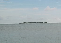
Isla de Cardona, Ponce, Puerto Rico, as seen from Club Nautico de Ponce on Isla de Gatas, Ponce, PR, looking Southwest
|
|
|
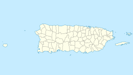
Cardona, Ponce, Puerto Rico
|
|
| Geography | |
|---|---|
| Location | Ponce, Puerto Rico |
| Coordinates | 17°57′24″N 66°38′6″W / 17.95667°N 66.63500°W |
| Area | 0.04 km2 (0.015 sq mi) |
| Administration | |
|
United States
|
|
| Commonwealth | Puerto Rico |
| Municipality | Ponce |
| Demographics | |
| Population | 0 |
| Pop. density | 0 /km2 (0 /sq mi) |
Coordinates: 17°57′24″N 66°38′6″W / 17.95667°N 66.63500°W
Cardona, also known as Sor Isolina Ferré Island, is a small, uninhabited island located 1.30 nautical miles south of the mainland Puerto Rican shore across from Barrio Playa, on the west side of the entrance to the harbor of Ponce, Puerto Rico. The small island is considered part of barrio Playa. It is home to the 1889 Cardona Island Light, which is listed in the U.S. National Register of Historic Places. Together with Caja de Muertos, Gatas, Morrillito, Ratones, Isla del Frio, and Isla de Jueyes, Cardona is one of seven islands ascribed to the municipality of Ponce. The island gained notoriety in 2010 when the Puerto Rican Bird Society made it a target for the eradication of the black rat.
The island, sometimes erroneously called a cay (or, key), is located at latitude 17°57"24.3' and longitude -66°38'5.9' (latitude 17.95672N, longitude: -66.634982W). The short distance from the mainland shore makes Cardona a popular landing point for aquatic events such as kayaking.
...
Wikipedia

