Isla Navarino
| Native name: Isla Navarino or Shunuko (Yamana) | |
|---|---|

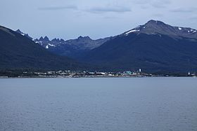
Puerto Williams and as background, Dientes de Navarino
|
|
| Geography | |
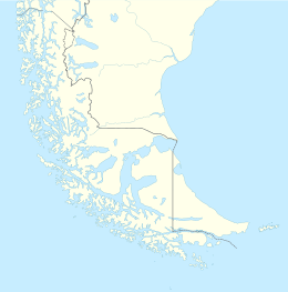
| Coordinates | 55°04′32″S 67°39′19″W / 55.0755°S 67.6553°WCoordinates: 55°04′32″S 67°39′19″W / 55.0755°S 67.6553°W |
| Adjacent bodies of water | Pacific ocean |
| Area | 2,473 km2 (955 sq mi) |
| Administration | |
| Region | Magallanes |
| Province | Antártica Chilena |
| Commune | Cabo de Hornos, Chile |
| Demographics | |
| Population | ~2,000 |
| Additional information | |
| NGA UFI=-893346 | |
Navarino Island (Spanish: Isla Navarino) is a Chilean island located between Isla Grande de Tierra del Fuego, to the north, and Cape Horn, to the south. The island forms part of the Commune of Cabo de Hornos, the southernmost commune in Chile and in the world, belonging to Antártica Chilena Province in the XII Region of Magallanes and Chilean Antarctica. It constitutes the nearest land to the Antarctic continent. Its population is concentrated primarily in the communal capital, Puerto Williams, and in small settlements like Puerto Navarino, Río Guanaco and Puerto Toro. The highest point of the island is Pico Navarino at 1,195 m (3,921 ft).
The indigenous people were Yahgan, estimated to have migrated to Tierra del Fuego more than 10,000 years ago by a land bridge that has since been submerged. From there, they went by canoe to other islands.
History and archaeology may be the most valuable resource of Navarino Island and its adjacent sectors. It is considered to have one of the most dense concentrations of archeological sites in the world. The Yahgan were nomadic people, and moved their settlements on a seasonal basis. Their middens show their dependence of fish and shellfish for food, as well as some vegetables that they gathered.
There is a Megalithic Yaghan archaeological site dating to about 10,000 years ago near Wulaia Bay, which C. Michael Hogan terms the Bahia Wulaia Dome Middens. Numerous remains of huts surrounded by ring middens have been found on the lowland terraces.
...
Wikipedia

