Ise (river)
| Ise | |
|---|---|

|
|
| Location |
Saxony-Anhalt, Lower Saxony, |
| Basin features | |
| Main source | west of Neuekrug 74 m above sea level (NN) 52°46′16″N 10°46′12″E / 52.77111°N 10.77°ECoordinates: 52°46′16″N 10°46′12″E / 52.77111°N 10.77°E |
| River mouth | In the centre of Gifhorn into the Aller 51 m above sea level (NN) 52°29′05″N 10°32′22″E / 52.4847389°N 10.539475°E |
| Progression | Aller → Weser → North Sea |
| River system | Weser |
| Basin size | 421.1 km² |
| Landmarks |
|
| Tributaries |
|
| Waterbodies | Lakes: Mühlensee und Schlosssee |
| Physical characteristics | |
| Length | 50 km |
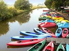
The Ise is a roughly 50 km long, almost natural river in East Lower Saxony, Germany, which crosses the district of Gifhorn from north to south and discharges into the Aller at Gifhorn itself.
The source of the Ise lies at a height of 74 metres (243 ft) above sea level and its mouth at 51 metres (167 ft). The river is about 50 km long and its slope of 0.05% is very gentle. The waters of the Ise flow via the Aller and Weser into the North Sea.
The Ise is formed west of Neuekrug in Saxony-Anhalt, immediately on the old Inner German Border with Lower Saxony, by the confluence of several small streams. In this Lower Saxony border region the river often runs dry in summer, but below the point where it is joined by the Rade ditch (Graben) its water flow is more consistent.
From there the Ise flows by the villages of Stöcken, Wollersdorf, Wentorf, Hankensbüttel, Alt Isenhagen, Wunderbüttel, Schönewörde, Wahrenholz, Wagenhoff, Neudorf-Platendorf, Käsdorf and Gamsen to Gifhorn. The river's only water level gauge (Pegel) is located near Neudorf-Platendorf, 13.4 km from its mouth.
Just before Gifhorn the Ise feeds the castle moat in Gifhorn as well as the Mühlensee lake, on which the Gifhorn Mill Museum stands. In Gifhorn's town centre the Ise meets the Aller, shortly after the point where it is dammed to power a mill. In older lexica, Gifhorn is characterised as an old 'marsh castle' (Sumpfburg) on the two rivers.
...
Wikipedia
