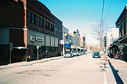
Irwin, Pennsylvania
| Irwin, Pennsylvania | |
|---|---|
| Borough | |

Irwin's Main Street
|
|
| Coordinates: 40°19′40″N 79°42′11″W / 40.32778°N 79.70306°WCoordinates: 40°19′40″N 79°42′11″W / 40.32778°N 79.70306°W | |
| Country | United States |
| State | Pennsylvania |
| County | Westmoreland |
| Settled | September 1853 |
| Incorporated | November 14, 1864 |
| Government | |
| • Type | Borough Council |
| Area | |
| • Total | 0.9 sq mi (2 km2) |
| Elevation | 324 ft (99 m) |
| Population (2000) | |
| • Total | 4,366 |
| • Density | 4,947.0/sq mi (1,910.0/km2) |
| Time zone | Eastern (EST) (UTC-5) |
| • Summer (DST) | EDT (UTC-4) |
| Zip code | 15642 |
| Area code(s) | 724 Exchanges: 861,863,864 |
| Website | http://www.downtownirwin.com |
Irwin is a borough in Westmoreland County, Pennsylvania, 22 miles (35 km) southeast of Pittsburgh. Some of the most extensive bituminous coal deposits in the State are located here. In the past, iron foundries, flour mills, car shops, facing and planing mills, electricals goods, and mirror factories provided employment to the residents. In 1900, the population numbered 2,452; it increased to 2,886 in 1910. The population was 3,973 at the 2010 census.
Irwin was named for John Irwin, the original owner of the town site.
Brush Hill was listed on the National Register of Historic Places in 1975.
According to the United States Census Bureau, the borough has a total area of 0.9 square miles (2.3 km2), all of it land.
As of the census of 2000, there were 4,366 people, 2,084 households, and 1,131 families residing in the borough. The population density was 4,947.0 people per square mile (1,915.6/km2). There were 2,277 housing units at an average density of 2,580.0 per square mile (999.0/km2). The racial makeup of the borough was 96.61% White, 1.01% African American, 0.09% Native American, 1.19% Asian, 0.02% Pacific Islander, 0.37% from other races, and 0.71% from two or more races. Hispanic or Latino of any race were 0.66% of the population.
...
Wikipedia

