Irvine, Kentucky
| Irvine, Kentucky | |
|---|---|
| City | |

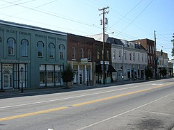
Downtown Irvine
|
|
 Location of Irvine, Kentucky |
|
| Coordinates: 37°41′49″N 83°58′1″W / 37.69694°N 83.96694°WCoordinates: 37°41′49″N 83°58′1″W / 37.69694°N 83.96694°W | |
| Country | United States |
| State | Kentucky |
| County | Estill |
| Named for | William Irvine, an area pioneer |
| Area | |
| • Total | 1.49 sq mi (3.85 km2) |
| • Land | 1.41 sq mi (3.65 km2) |
| • Water | 0.08 sq mi (0.20 km2) |
| Elevation | 679 ft (207 m) |
| Population (2010) | |
| • Total | 2,715 |
| • Density | 1,927/sq mi (744.2/km2) |
| Time zone | Eastern (EST) (UTC-5) |
| • Summer (DST) | EDT (UTC-4) |
| ZIP codes | 40336, 40472 |
| Area code(s) | 606 |
| FIPS code | 21-39646 |
| GNIS feature ID | 0512925 |
Irvine (local /ərvən/ and /ərvaɪn/) is a home rule-class city in Estill County, Kentucky, in the United States. It is the seat of its county. Its population was 2,715 at the time of the 2010 census. It is located on the Kentucky River at the junction of Kentucky Route 52 and Kentucky Route 89.
Irvine annually hosts the Mountain Mushroom Festival on the last weekend of April. Irvine and nearby Ravenna are known within Estill County as the "Twin Cities".
Irvine is located in the center of Estill County at 37°41′49″N 83°58′1″W / 37.69694°N 83.96694°W (37.696835, -83.966895). The city limits are on the northeast side of the Kentucky River, and the city is bordered by Ravenna to the southeast. According to the United States Census Bureau, Irvine has a total area of 1.49 square miles (3.85 km2), of which 1.41 square miles (3.65 km2) is land and 0.077 square miles (0.20 km2), or 5.13%, is water.
...
Wikipedia
