Irkestam
|
Erkeshtam Эркеч-Там |
|
|---|---|

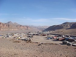
Trucks waiting to cross into China in the village of Erkeshtam
|
|
| Coordinates: 39°40′48″N 73°54′36″E / 39.68000°N 73.91000°ECoordinates: 39°40′48″N 73°54′36″E / 39.68000°N 73.91000°E | |
| Country |
|
| Region | Osh Region |
| Elevation | 3,005 m (9,859 ft) |
| Time zone | UTC +6 |
| Irkeshtam Pass | |
|---|---|
| Elevation | 2,950 m (9,678 ft) |
| Traversed by | Asian Highway 65 (AH65) |
| Location |
|
| Range | Tian Shan / Pamir Range |
| Coordinates | N 39°42', E 73°58' |
Erkeshtam, also Irkeshtam or Erkesh-tam (Chinese: 伊尔克什坦), is a border crossing between Kyrgyzstan and Xinjiang, China, named after a village on the Kyrgyz side of the border in southern Osh Region. The border crossing is also called Simuhana (斯姆哈纳), after the first settlement on the Chinese side of the border, but Irkeshtam is now the more common name used in both countries.
Erkeshtam is the westernmost border crossing in China. It is one of two border crossings between Kyrgyzstan and China, the other being Torugart, some 165 km (103 mi) to the northeast. The overland travel distance from Erekshtam to Osh is 210 km (130 mi), about 800 km (500 mi) shorter than via the Torugart Border Crossing.
Erkeshtam Border Crossing strategically located about 230 kilometres (140 mi) west of Kashgar, 250 kilometres (160 mi) southeast of Osh and 550 kilometres (340 mi) east of Dushanbe, Tajikistan. The crossing staddles the Irkeshtam Pass, a deep gorge where the southern flank of the Tian Shan meets the Pamir Mountains. The elevation of the gorge is approximately 2,950 metres (9,680 ft) above sea level. The village of Erkeshtam is situated about 2 kilometres (1.2 mi) from the Kyrgyz-Chinese border. Both Irkeshtam and the village of Simuhana, about 3.5 kilometres (2.2 mi) on the Chinese side of the border, are situated along the Kizilesu River. Simuhana belongs to Ulugqat County, under the Kizilsu Kirghiz Autonomous Prefecture of Xinjiang.
The Erkeshtam Border Crossing controls the main trade routes between the Tarim Basin to the east, and the Alay and Ferghana Valleys to the west and north.
From the Kyrgyz side of the border, the A372 road goes west over a pass into the Alay Valley. At Sary-Tash, the A372 meets the M41 highway, which leads north through the Taldyk Pass (elevation 3,615 metres (11,860 ft) to Osh and the Ferghana Valley.
...
Wikipedia

