Iowa Highway 28
| Iowa Highway 28 | ||||
|---|---|---|---|---|
 |
||||
| Route information | ||||
| Maintained by Iowa DOT | ||||
| Length: | 21.613 mi (34.783 km) | |||
| Major junctions | ||||
| South end: |
|
|||
|
||||
| North end: |
|
|||
| Location | ||||
| Counties: | ||||
| Highway system | ||||
|
||||
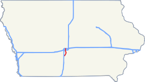
Iowa Highway 28 is a 21.73-mile-long (34.97 km) state highway located in south central Iowa. The route begins at Iowa Highway 92 at Martensdale and ends at Interstate 35 / Interstate 80 in Johnston. It is the first major north–south highway east of Interstate 35 in the Des Moines metropolitan area.
Iowa Highway 28 begins at Iowa Highway 92 at Martensdale in Warren County. From Martensdale, it continues north through Prole and Norwalk before crossing into Polk County. Just across the county line, Iowa 28 meets Iowa Highway 5 at a partial-cloverleaf interchange. Just north of the interchange is Army Post Road, a former alignment of Iowa Highway 5. Iowa 28 crosses the Raccoon River just south of Railroad Avenue in West Des Moines. From the river to the Interstate 235 interchange, the east side of the street is 63rd Street in Des Moines, while the west side of the street is 1st Street in West Des Moines. The dual designation of street names is particularly confusing to drivers and residents alike. North of I-235, Iowa 28 continues north through Windsor Heights until reaching U.S. Route 6 at Hickman Road in Des Moines. U.S. Route 6 and Iowa Highway 28 run together for 1.32 miles (2.12 km), first east on Hickman Road, then north on Merle Hay Road. US 6 and Iowa 28 split at Douglas Avenue near Merle Hay Mall. Iowa 28 continues north along the Urbandale / Des Moines city limit line before ending at exit 131 of Interstate 35 / Interstate 80 at the Johnston / Urbandale city limit line.
...
Wikipedia

