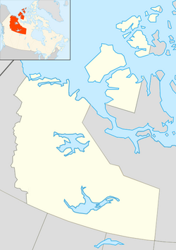
Inuvik, Northwest Territories
|
Inuvik Inuuvik |
||
|---|---|---|
| Town | ||

Buildings of central Inuvik from south of town
|
||
|
||
| Coordinates: 68°21′42″N 133°43′50″W / 68.36167°N 133.73056°WCoordinates: 68°21′42″N 133°43′50″W / 68.36167°N 133.73056°W | ||
| Country | Canada | |
| Territory | Northwest Territories | |
| Region | Inuvik Region | |
| Constituency |
Inuvik Boot Lake Inuvik Twin Lakes |
|
| Census division | Region 1 | |
| Settled | 1954 | |
| Village | 1 April 1967 | |
| Town | 1 January 1970 | |
| Government | ||
| • Mayor | Jim McDonald | |
| • SAO | Grant Hood | |
| • MLA | Robert C. McLeod (Twin Lakes) | |
| • MLA | Alfred Moses (Boot Lake) | |
| • MP | Michael McLeod | |
| Area | ||
| • Land | 62.48 km2 (24.12 sq mi) | |
| • Population centre | 5.85 km2 (2.26 sq mi) | |
| Elevation | 15 m (49 ft) | |
| Highest elevation | 68 m (223 ft) | |
| Lowest elevation | 10 m (30 ft) | |
| Population (2006) | ||
| • Total | 3,463 | |
| • Density | 55.4/km2 (143/sq mi) | |
| • Population centre | 3,403 | |
| • Population centre density | 581.4/km2 (1,506/sq mi) | |
| Time zone | Mountain (MST) (UTC−7) | |
| • Summer (DST) | MDT (UTC−6) | |
| Canadian Postal code | X0E 0T0 | |
| Area code(s) | 867 | |
| Telephone exchange | 678/777 (777 was previously (403) 979) | |
| - Living cost | 147.5 | |
| - Food price index | 149.8 | |
| Highways | Dempster Highway | |
| Waterways | Mackenzie River | |
| Climate | Dfc | |
| Website | www |
|
| Sources: Department of Municipal and Community Affairs, Prince of Wales Northern Heritage Centre, Canada Flight Supplement ^A 2009 figure based on Edmonton = 100 ^B 2010 figure based on Yellowknife = 100 |
||
Inuvik /ᵻˈnuːvɪk/ (place of man) is a town in the Northwest Territories of Canada and is the administrative centre for the Inuvik Region.
The population as of the 2011 Census was 3,484, a decrease of 0.6% from the 2006 Census. The two previous census counts show wide fluctuations due to economic conditions: 2,894 in 2001 and 3,296 in 1996. In 2012 the Government of the Northwest Territories reported that the population was 3,321 with an average yearly growth rate of 0.2% from 2001.
Inuvik was conceived in 1953 as a replacement administrative centre for the hamlet of Aklavik on the west of the Mackenzie Delta, as the latter was prone to flooding and had no room for expansion. Initially called "New Aklavik", it was renamed Inuvik in 1958. The school was built in 1959 and the hospital, government offices and staff residences in 1960, when people began to live in the community: Inuvialuit, Dene and Métis.
Naval Radio Station (NRS) Inuvik, callsign CFV, was commissioned on 10 September 1963 after operations had been successfully transferred from NRS Aklavik. Station CFV was part of the SUPRAD (Supplementary Radio) network of intercept and direction finding stations.
CFS Inuvik closed on 1 April 1986 and the site was transferred to the Dept. of Transport for use as a telecommunications station. Nothing remains of CFS Inuvik today. Even now, many people of all backgrounds still lament its closing. The Navy Operations base at the end of Navy Road was completely dismantled and removed.
...
Wikipedia


