Interstate 22 in Alabama
| Interstate 22 | |||||||
|---|---|---|---|---|---|---|---|

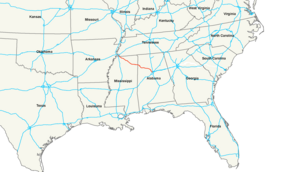
Interstate 22 highlighted in red.
|
|||||||
| Route information | |||||||
| Length: | 213.0 mi (342.8 km) | ||||||
| Existed: | 2012 – present | ||||||
| Major junctions | |||||||
| West end: |
|
||||||
|
|||||||
| East end: |
|
||||||
| Location | |||||||
| States: | Mississippi, Alabama | ||||||
| Highway system | |||||||
|
|||||||
| Interstate 222 | |
|---|---|
| Location: | Birmingham, Ala. |
| Length: | 2.26 mi (3.64 km) |
Interstate 22 (I-22) is an Interstate Highway that follows the U.S. Route 78 (US 78) corridor on a 213-mile-long (343 km) route from Byhalia, Mississippi south of Memphis, Tennessee, to Birmingham, Alabama. I-22 indirectly connects I-240, I-40, I-55, and I-69 in the northwest with I-65 and I-20/I-59 in the southeast. When designated in 2012, it was designed to close a gap in the Interstate network allowing more direct connections between cities in the southeast (such as Atlanta and Birmingham) with those of the Great Plains (such as Oklahoma City and St. Louis).
Along its way through the two states, I-22 serves the towns of Jasper, Winfield, and Hamilton, Alabama and Fulton, Tupelo, New Albany, and Holly Springs, Mississippi. All portions of this highway were either built new or converted to Interstate Highway standards as of early 2011. A future interchange with I-269 near Byhalia, Mississippi is the western terminus of I-22. The eastern terminus is at an interchange with I-65 in Jefferson County, north of Birmingham.
...
Wikipedia

