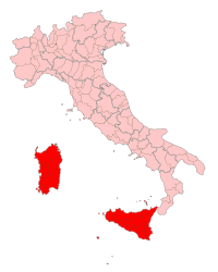
Insular Italy
 |
|
| Regional statistics | |
|---|---|
| Composition |
|
|
Area - Total |
49,801 km2 (19,228 sq mi) |
|
Population - Total - Density |
6,725,772 (2010 est.) 135/km2 (349.8/sq mi) |
| Largest city | Palermo (pop. 654,227) |
| GDP | €117.7 billion (2008) |
Insular Italy (Italian: Italia insulare or just ) is one of the five official statistical regions of Italy used by the National Institute of Statistics (ISTAT), a first level NUTS region and a European Parliament constituency. Insular Italy encompasses two of the country's 20 regions: Sardinia and Sicily.
Insular Italy occupies one-sixth of the national territory in surface area. Territorially, both Sicily and Sardinia include several minor islands and archipelagoes administratively dependent on the mother islands.
Sicily is the largest island in the Mediterranean (25,708 km2) and one of the largest of Europe, while Sardinia is only slightly less extensive (24,090 km2). The lowlands are generally limited in the geographic region and generally appear as narrow coastal belts. The only exceptions are the Campidano and Nurra in Sardinia and the Plain of Catania in Sicily that extend 1200 km2 and 430 km2 respectively. The rest of the area is prevalently hilly, with hills occupying 70% of the territory. Sicily is home to Mount Etna, Italy's highest non-Alpine peak and Europe's largest active volcano. Sardinia is home to the Gennargentu mountain range.
The population of Insular Italy totals combined over 6.7 million residents. Insular Italy has a population density of less than half the national average mainly because of the scarce population of Sardinia, one of the least densely populated regions of Italy and Europe. Sicily, on the other hand, has in fact a population density five times higher than Sardinia.
...
Wikipedia
