Inniswold, Louisiana
| Inniswold, Louisiana | |
| Census-designated place | |
| Country | United States |
|---|---|
| State | Louisiana |
| Parish | East Baton Rouge |
| Elevation | 30 ft (9.1 m) |
| Coordinates | 30°24′02″N 91°04′18″W / 30.40056°N 91.07167°WCoordinates: 30°24′02″N 91°04′18″W / 30.40056°N 91.07167°W |
| Area | 2.2 sq mi (5.7 km2) |
| - land | 2.2 sq mi (6 km2) |
| - water | 0.0 sq mi (0 km2), 0% |
| Population | 6,180 (2010) |
| Density | 2,762.7/sq mi (1,066.7/km2) |
| Timezone | CST (UTC-6) |
| - summer (DST) | CDT (UTC-5) |
| Area code | 225 |
|
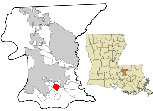
Location in East Baton Rouge Parish and the state of Louisiana.
|
|
|
Location of Louisiana in the United States
|
|
Inniswold is an unincorporated area and census-designated place (CDP) in East Baton Rouge Parish, Louisiana, United States. The population was 6,180 at the 2010 census, up from 4,944 at the 2000 census. It is part of the Baton Rouge Metropolitan Statistical Area.
Inniswold is located in southern East Baton Rouge Parish at 30°24′2″N 91°4′18″W / 30.40056°N 91.07167°W (30.400658, -91.071652). It is bordered to the west, across Bluebonnet Road, by Westminster. Jefferson Highway (Louisiana Highway 73) forms the northern border, Siegen Lane the eastern border, and Interstate 10 the southern border. Access from Interstate 10 is from Exits 162 and 163. The center of Baton Rouge is 8 miles (13 km) to the northwest.
According to the United States Census Bureau, the Inniswold CDP has a total area of 2.2 square miles (5.8 km2), all land.
As of the census of 2000, there were 4,944 people, 2,060 households, and 1,347 families residing in the CDP. The population density was 2,272.7 people per square mile (875.6/km²). There were 2,158 housing units at an average density of 992.0 per square mile (382.2/km²). The racial makeup of the CDP was 80.48% White, 15.25% African American, 0.14% Native American, 2.31% Asian, 1.09% from other races, and 0.73% from two or more races. Hispanic or Latino of any race were 2.16% of the population.
...
Wikipedia


