Inis Cealtra
| Native name: Inis Cealtra | |
|---|---|

St. Caimin's and Brigid's churches
|
|
| Geography | |
| Location | Lough Derg (Shannon) |
| Coordinates | 52°54′54″N 8°27′0″W / 52.91500°N 8.45000°WCoordinates: 52°54′54″N 8°27′0″W / 52.91500°N 8.45000°W |
| Administration | |
| Province | Munster |
| County | Clare |
| Demographics | |
| Population | 0 |
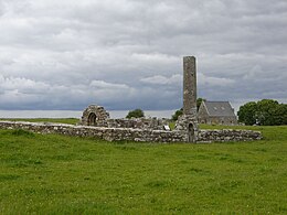
Inis Cealtra, or Holy Island, is an island off the western shore of Lough Derg in Ireland. Now uninhabited, it was once a monastic settlement. It has an Irish round tower, and the ruins of several small churches, as well as part of 4 high crosses and a holy well. The cemetery on this island is still in use, coffins and mourners being transported the short distance from County Clare in small boats. Boat trips can be taken from the harbour at Mountshannon. It is conserved by the East Clare Heritage Centre.
Around 520 CE, St. Colum, (Died 548 CE), founded a monastery on Inis Cealtra. It formerly belonged to the Cenél Donnghaile in the territory of the Ó Gradys. The second monastery, a famous school of learning, was founded by St. Caimin, (Died 653 CE), who was Bishop-Abbot of Inis Cealtra and possibly the first Bishop of Killaloe.Vikings visited the island in 836; led by Turgesius, they killed many of the monks. A further Viking attack led by Tomran took place in 922. Marcán, brother of Brian Boru, was Bishop-Abbot of Tuamgraney and later Inis Cealtra until his death in 1003. The religious buildings of Inis Cealtra were not occupied after the reformation.
Until 1849, the island was part of County Clare, even though the adjoining shore of the mainland was in County Galway. In 1849, the island was transferred to Galway as part of Griffith's Valuation, which was mandated to eliminate detached portions of counties. However, in 1899, the district electoral division containing both the island and adjoining mainland was transferred from Galway to Clare under the Local Government (Ireland) Act 1898.
...
Wikipedia

