Ingavi
| Ingavi Province | |
|---|---|
| Province | |

|
|
 Location of Ingavi Province within Bolivia |
|
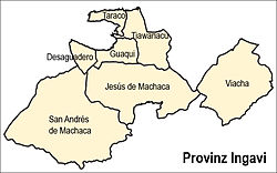
 Map of municipalities of Ingavi |
|
| Coordinates: 16°43′0″S 68°50′0″W / 16.71667°S 68.83333°W | |
| Country |
|
| Department | La Paz Department |
| Municipalities | 7 |
| Capital | Viacha |
| Area | |
| • Total | 5,410 km2 (2,090 sq mi) |
| Population (2012 census) | |
| • Total | 134,535 |
| • Density | 25/km2 (64/sq mi) |
| • Ethnicities | Aymara |
| Website | Official website |
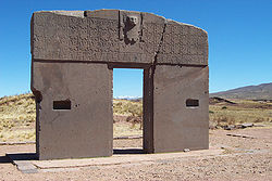
Ingavi is a province in the La Paz Department in Bolivia. This is where the Battle of Ingavi occurred on November 18, 1841 and where the World Heritage Site of Tiwanaku is situated.
During the presidency of Eliodoro Villazón the province was founded on December 16, 1909 with Viacha as its capital.
Ingavi lies on the southern shore of Lake Titicaca. The Chilla-Kimsa Chata mountain range traverses the province. Some of the highest mountains of the province are listed below:
Ingavi Province is divided into seven municipalities which are partly further subdivided into cantons.
The people are predominantly indigenous citizens of Aymara descent.
Some of the tourist attractions of the municipalities are:
Coordinates: 16°43′S 68°50′W / 16.717°S 68.833°W
...
Wikipedia
