Indore
|
Indore इंदौर |
|
|---|---|
| Metropolis | |

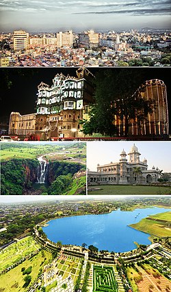
Clockwise from top: Skyline of Mangal City Area (Vijay Nagar), Rajwada Palace, Daly College, Atal Bihari Vajpayee Regional Park aerial view, Patalpani Waterfalls
|
|
| Nickname(s): Street Food Capital of India | |
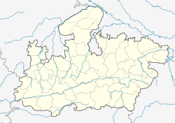
| Location of Indore in Madhya Pradesh | |
| Coordinates: 22°43′0″N 75°50′50″E / 22.71667°N 75.84722°ECoordinates: 22°43′0″N 75°50′50″E / 22.71667°N 75.84722°E | |
| Country |
|
| State | Madhya Pradesh |
| Region | Malwa |
| District | Indore District |
| Ward | 85 Wards |
| Government | |
| • Type | Mayor–Council |
| • Body | Indore Municipal Corporation |
| • Mayor | Malini Laxmansingh Gaur (BJP) |
| • District Collector | P. Narahari |
| • Municipal Commissioner | Manish Singh |
| • Member of Parliament | Sumitra Mahajan (Now Speaker in Lok Sabha (2014 - till date)) |
| Area | |
| • Metropolis | 389.8 km2 (150.5 sq mi) |
| Area rank | 11 |
| Elevation | 564 m (1,850 ft) |
| Population (2011) | |
| • Metropolis | 2,170,295 |
| • Rank | 14th |
| • Density | 5,116.4/km2 (13,251/sq mi) |
| • Metro | 3,254,238 |
| • Metro rank | 15th |
| Demonym(s) | Indori, Indorian |
| Time zone | IST |
| PIN | 4520XX |
| Telephone code | 0731 |
| Vehicle registration | MP-09-XXXX |
| Sex ratio | Female 927 Male 1000 |
| Literacy Rate | 80.63% |
| HDI | High |
| Climate | Cwa / Aw (Köppen) |
| Precipitation | 945 millimetres (37.2 in) |
| Avg. annual temperature | 24.0 °C (75.2 °F) |
| Avg. summer temperature | 31 °C (88 °F) |
| Avg. winter temperature | 17 °C (63 °F) |
| Website | www |
Indore ![]() i/ɪnˈdɔər/ (Devanāgarī: इंदौर), is the largest and most populous city of the Indian state of Madhya Pradesh. It serves as the headquarters of both Indore District and Indore Division. Indore was described by the Economic Times as the commercial capital of the state. It is also considered as an education hub of the state and houses campuses of both the Indian Institute of Technology and the Indian Institute of Management. Located on the southern edge of Malwa Plateau, the city is 190 km west of the state capital of Bhopal. With a census-estimated 2011 population of 2,170,295 (municipal corporation) and 3,254,238 (urban agglomeration), the Indore Metropolitan Area's population is the state's largest. The city is distributed over a land area of just 530 square kilometers making Indore the most densely populated major city in the central province. It comes under Tier 2 cities in India.
i/ɪnˈdɔər/ (Devanāgarī: इंदौर), is the largest and most populous city of the Indian state of Madhya Pradesh. It serves as the headquarters of both Indore District and Indore Division. Indore was described by the Economic Times as the commercial capital of the state. It is also considered as an education hub of the state and houses campuses of both the Indian Institute of Technology and the Indian Institute of Management. Located on the southern edge of Malwa Plateau, the city is 190 km west of the state capital of Bhopal. With a census-estimated 2011 population of 2,170,295 (municipal corporation) and 3,254,238 (urban agglomeration), the Indore Metropolitan Area's population is the state's largest. The city is distributed over a land area of just 530 square kilometers making Indore the most densely populated major city in the central province. It comes under Tier 2 cities in India.
Indore traces its roots to its 16th century founding as a trading hub between the Deccan and Delhi. The city and its surroundings came under Hindu Maratha Empire on 18 May 1724 after Maratha Peshwa Baji Rao I assumed the full control of Malwa. During the days of the British Raj, Indore State was a 19 Gun Salute (21 locally) princely state (a rare high rank) ruled by the Maratha Holkar dynasty, until they acceded to the Union of India. Indore served as the capital of the Madhya Bharat from 1950 until 1956.
...
Wikipedia

