Indian Heights, Indiana
| Indian Heights, Indiana | |
|---|---|
| Neighborhood | |
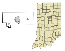
 Location in the state of Indiana |
|
| Coordinates: 40°25′43″N 86°7′7″W / 40.42861°N 86.11861°WCoordinates: 40°25′43″N 86°7′7″W / 40.42861°N 86.11861°W | |
| Country | United States |
| State | Indiana |
| County | Howard |
| Area | |
| • Total | 0.9 sq mi (2.2 km2) |
| • Land | 0.9 sq mi (2.2 km2) |
| • Water | 0.0 sq mi (0.0 km2) |
| Elevation | 856 ft (261 m) |
| Population (2010) | |
| • Total | 3,011 |
| • Density | 3,807/sq mi (1,469.9/km2) |
| Time zone | EST (UTC-5) |
| • Summer (DST) | EDT (UTC-4) |
| FIPS code | 18-36144 |
| GNIS feature ID | 0436762 |
Indian Heights is a neighborhood in Kokomo, Howard County, Indiana, United States. Indian Heights was a census-designated place (CDP) also before its annexation into Kokomo. The population was 3,011 at the 2010 census. It is part of the Kokomo, Indiana Metropolitan Statistical Area. On January 1, 2012, the neighborhood of Indian Heights was legally annexed into the city of Kokomo's corporate boundary.
Indian Heights is located at 40°25′43″N 86°07′07″W / 40.428737°N 86.118540°W.
According to the United States Census Bureau, the CDP has a total area of 0.9 square miles (2.3 km2), all land.
Built in 1956 by Lusk Corporation and U.S. Steel, Indian Heights was long an unincorporated community and CDP outside Kokomo, and prospered well. Kokomo however annexed Indian Heights into the city in 2012, and Indian Heights now receives emergency services from Kokomo rather than the county. Indian Heights still uses Taylor Schools though despite being in Kokomo since it is a part of Taylor Township.
By definition a CDP can not be an incorporated place, it can have no structured government, and has to be directly against another incorporated place, or have clearly defined natural boundaries. With that in mind Indian Heights is no longer eligible to be a CDP for Howard County. Instead it is possible for New London, Jerome, or Sycamore to take its place in the next election as they all fall under those guidelines.
...
Wikipedia
