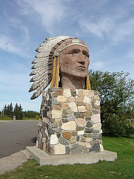
Indian Head, Saskatchewan
| Indian Head, Saskatchewan | |
|---|---|
| Town | |

Indian Head Statue
|
|
| Motto: Beautiful Historic Indian Head | |
| Coordinates: 50°19′12″N 103°24′00″W / 50.320°N 103.400°W | |
| Country | Canada |
| Province | Saskatchewan |
| Region | South Eastern Saskatchewan |
| Census division | 6 |
| Rural Municipality | Indian Head |
| Established | 1882 |
| Incorporated (Town) | 1902 |
| Government | |
| • Mayor | Steven Cole |
| • Governing body | Indian Head Town Council |
| Area | |
| • Total | 3.17 km2 (1.22 sq mi) |
| Population (2016) | |
| • Total | 1,910 |
| • Density | 602/km2 (1,560/sq mi) |
| Time zone | CST |
| Postal code | S0G 2K0 |
| Area code(s) | 306 |
| Highways |
Trans-Canada Highway Highway 56 |
| Website | Town of Indian Head |
Indian Head is a town in southeast Saskatchewan, Canada, 69 kilometres (43 mi) east of Regina. The town is directly north of the Trans-Canada Highway. It "had its beginnings in 1882 as the first settlers, mainly of Scottish origin, pushed into the area in advance of the railroad, most travelling by ox-cart from Brandon." The town is known for its federally operated experimental farm and tree nursery, which has produced and distributed seedlings for shelter belts since 1901. For many years the programme was run by the Prairie Farm Rehabilitation Administration (PFRA).
It was incorporated as a town in 1902. In that year the Canadian Journal, published by James McAra, noted that Indian Head was the largest point of initial shipment of wheat in the world. Today it is run by the Agroforestry Development Centre. Today "[the town] has a range of professional services and tradespeople, financial institutions, and a large number of retail establishments." The television sitcom Little Mosque on the Prairie which aired on CBC Television 2007-12 was filmed in Toronto, Ontario and Indian Head.
Indian Head is located in the Indian Head Plain of the Aspen Parkland ecoregion on the parkland of the Qu'Appelle flood plain. Qu'Appelle's elevation is 579.10 m (1,899.9 ft) above sea level placing it within the topographical region of the Squirrel Hills. The area is characterised by lush rolling grasslands, interspersed with poplar bluffs (in prairie Canadian terminology poplar groves surrounding sloughs) and open sloughs. Indian Head is located in the transition zone between the Qu'Appelle River and the corresponding Qu'Appelle Valley and the Canadian Prairies. The Indianhead Creek flows through Indian Head into the Qu'Appelle River to the north. The legal land description is section 24 - township 18 - range 13 - west of the 2nd meridian. 10 miles (16 km) north of Indian Head are the Fishing Lakes which are part of the Qu'Appelle Valley.
...
Wikipedia

