Independence Pass (Colorado)
| Independence Pass | |
|---|---|

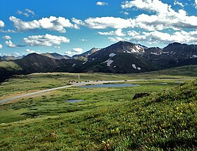
View across pass from slopes of unnamed peak to the north
|
|
| Elevation | 12,095 feet (3,687 m) NAVD 88 |
| Traversed by |
|
| Location |
Lake / Pitkin counties, Colorado, U.S. |
| Range | Sawatch |
| Coordinates | 39°06′29″N 106°33′52″W / 39.10806°N 106.56444°WCoordinates: 39°06′29″N 106°33′52″W / 39.10806°N 106.56444°W |
| Topo map | USGS Independence Pass |
| Colorado | |
Independence Pass, originally known as Hunter Pass, is a high mountain pass in the Rocky Mountains of central Colorado in the United States. It is at elevation 12,095 ft (3,687 m) on the Continental Divide in the Sawatch Range. The pass is midway between Aspen and Twin Lakes, on the border between Pitkin and Lake counties.
State Highway 82 traverses it, in the process reaching the highest elevation of a paved Colorado state highway on a through road. After Cottonwood Pass to the south, it is the second-highest pass with an improved road in the state, the fourth-highest paved road in the state and the highest paved crossing of the Continental Divide in the U.S. Because of the heavy snowfall at its elevation, it is closed in wintertime, isolating Aspen from direct access from the east during the ski season.
When the pass is open in warmer weather, it is a popular destination. A scenic overlook near the pass allows visitors to take in the alpine tundra environment above treeline, and offers excellent views to the east of Mount Elbert, Colorado's highest peak and the second-highest mountain in the contiguous United States. Rock climbers are drawn to nearby bouldering opportunities, and informal paths lead to nearby mountain summits of even higher elevation. Backcountry skiers make use of the slopes during the late spring and early summer. Since 2011 the pass has been on the route of the USA Pro Cycling Challenge.
...
Wikipedia

