Inagi, Tokyo
|
Inagi 稲城市 |
|||
|---|---|---|---|
| City | |||

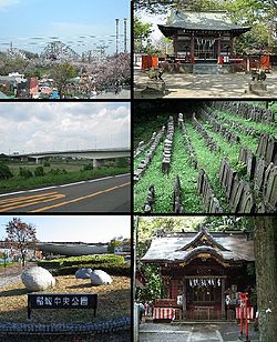
Clockwise from top left: Yomiuri Land Amusement Park, Aoi Shrine, Stone Buddha Statue in Mount Arigata, Anazawa-ten Shrine, Inagi Central Park, Inagi Bridge
|
|||
|
|||
 Location of Inagi in Tokyo |
|||
| Coordinates: 35°38′16.6″N 139°30′16.4″E / 35.637944°N 139.504556°ECoordinates: 35°38′16.6″N 139°30′16.4″E / 35.637944°N 139.504556°E | |||
| Country | Japan | ||
| Region | Kantō | ||
| Prefecture | Tokyo | ||
| Area | |||
| • Total | 17.97 km2 (6.94 sq mi) | ||
| Population (February 2016) | |||
| • Total | 87,927 | ||
| • Density | 4,890/km2 (12,700/sq mi) | ||
| Time zone | Japan Standard Time (UTC+9) | ||
| Symbols | |||
| • Tree | Ginkgo biloba | ||
| • Flower | Pyrus pyrifolia | ||
| Phone number | 042-378-2111 | ||
| Address | 2111 Higashi-Naganuma, Inagi-shi, Tokyo 206-8601 | ||
| Website | www |
||
Inagi (稲城市 Inagi-shi?) is a city located in the western portion of Tokyo Metropolis, in the central Kantō region of Japan. As of 1 February 2016[update], the city had an estimated population of 87,927 and a population density of 4890 persons per km². Its total area was 17.97 square kilometres (17,970,000 m2).
Inagi is located in the south-central portion of Tokyo Metropolis, approximately 25 kilometers from the center of Tokyo. The Tama River flows through the city, which is bordered by Kanagawa Prefecture to the south.
Inagi as a modern municipality was founded on April 1, 1889 as Inagi Village in what was then Minamitama District, Kanagawa Prefecture, from the merger of 6 pre-Meiji period villages with the establishment of the municipalites system. The district was transferred to the administrative control of Tokyo Metropolis on April 1, 1893.
On April 1, 1957, Inagi Village was reclassified as Inagi Town.
On November 1, 1971, Inagi Town was reclassified as Inagi City, dissolving Minamitama District. Inagi with Tama was the last town within the former Minamitama District.
Inagi is run by a city assembly with 22 elected members. The current mayor is Katsuhiro Takahashi, an independent.
...
Wikipedia


