Ilfracombe, Queensland
|
Ilfracombe Queensland |
|||||||||||||
|---|---|---|---|---|---|---|---|---|---|---|---|---|---|

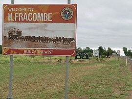
Town entry signs.
|
|||||||||||||
| Coordinates | 23°30′S 144°30′E / 23.500°S 144.500°ECoordinates: 23°30′S 144°30′E / 23.500°S 144.500°E | ||||||||||||
| Population | 348 (2011 census) | ||||||||||||
| Established | 1891 | ||||||||||||
| Postcode(s) | 4727 | ||||||||||||
| Elevation | 214 m (702 ft) | ||||||||||||
| Location |
|
||||||||||||
| LGA(s) | Longreach Region | ||||||||||||
| State electorate(s) | Gr egory | ||||||||||||
| Federal Division(s) | Maranoa | ||||||||||||
|
|||||||||||||
Ilfracombe /ˈɪlfrəkoʊm/ is a small town and locality in the Longreach Region in Central West Queensland, Australia. Ilfracombe calls itself The Hub of the West. The main industry is sheep rearing, mainly for wool. Ilfracombe is situated on the Landsborough Highway, about 27 kilometres (17 mi) east of Longreach, 214 metres above sea level. In the 2011 census, Ilfracombe had a population of 348 people.
Sheep stations were established in the area from 1864. The townsites of Ilfracombe and Longreach were amongst resumed portions of Wellshot Station. In 1892, Wellshot was known as the biggest sheep station in the world, not because of the area it occupied but because of the number of sheep it ran; 460,000. So important was the property that Ilfracombe was known as Wellshot until 1890. 40,000 two-year-old wethers were sold off from the property later the same year.
The Central Western railway line reached Ilfracombe in 1891 and the Post Office opened on 7 December 1891.
The town was named after the coastal town of Ilfracombe in North Devon, England.
At the 2006 census, Ilfracombe and the surrounding region had a population of 269. The town itself has a population of 190.
The town was much larger in the past. It once had three hotels instead of the single hotel now and two general stores.
...
Wikipedia

