Ilam, Nepal
|
Ilam ईलाम Charkhola |
|
|---|---|
| Municipality | |

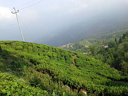
A tea estate in Ilam
|
|
| Motto: Hamro Ilam, Ramro Ilam | |
| Location in Nepal | |
| Coordinates: 26°54′30″N 87°55′35″E / 26.90833°N 87.92639°ECoordinates: 26°54′30″N 87°55′35″E / 26.90833°N 87.92639°E | |
| Country |
|
| Zone | Mechi Zone |
| District | Ilam District |
| Government | |
| • Type | Ilam Municipality |
| Population (2011) | |
| • Total | 19,427 |
| • Ethnicities | Limbu, Yakha, Sunuwar, brahmins, Rai, Gurung |
| • Religions | Hinduism, Buddhist and Kirat |
| Time zone | NST (UTC+5:45) |
| Postal Code | 57300 |
| Area code(s) | 027 |
| Language | limbu Nepali and English (in some offices) |
| Website | ilam |
Ilam (Nepali: इलाम ![]() Listen ) is a municipality of Ilam District, which is in the hilly region of Mechi zone, in the Eastern Development Region of Nepal. Ilam also acts as the headquarters of Ilam District and Mechi zone. Geographically it lies in the hill region which is mostly known as Mahabharata range. It is also one of the important town in Mechi zone and one of the major place in Nepal for tea-production. It is famous for natural scenery and landscapes, tea production, and diverse agricultural economy. It is one of the major horticultural crop production districts of Nepal. Ilam municipality is sub-divided in 9 different wards, the major governmental and district office lies in ward number 1 and ward number 2. Ilam also is a major hub for transportation and communication for VDC that lies in the upper part of the discrict.
Listen ) is a municipality of Ilam District, which is in the hilly region of Mechi zone, in the Eastern Development Region of Nepal. Ilam also acts as the headquarters of Ilam District and Mechi zone. Geographically it lies in the hill region which is mostly known as Mahabharata range. It is also one of the important town in Mechi zone and one of the major place in Nepal for tea-production. It is famous for natural scenery and landscapes, tea production, and diverse agricultural economy. It is one of the major horticultural crop production districts of Nepal. Ilam municipality is sub-divided in 9 different wards, the major governmental and district office lies in ward number 1 and ward number 2. Ilam also is a major hub for transportation and communication for VDC that lies in the upper part of the discrict.
The word ‘Ilam’ comprises two words-‘I’ and ‘Lam’. In Limbu language, the word ‘I’ means ‘winding’ and ‘lam’ denotes to the way. Upon looking at the topography of this land, we can actually see several winding paths crisscrossing on the way. Thus it is aptly named ‘Ilam’.
According to 2011 Nepal census, the total population in Ilam was 19,427 and the main inhabitants of Ilam were Limbu, Rai, Yakkha, Lepcha, Newar, Magar, Tamang, Chettri, Brahmin, Sunuwar and Gurung.
...
Wikipedia

