Iida, Nagano
|
Iida 飯田市 |
|||
|---|---|---|---|
| City | |||

Overview of Iida City
|
|||
|
|||
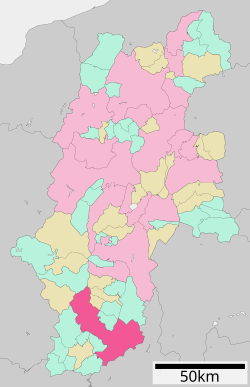
 Location of Iida in Nagano Prefecture |
|||
| Coordinates: 35°30′54″N 137°49′17″E / 35.51500°N 137.82139°ECoordinates: 35°30′54″N 137°49′17″E / 35.51500°N 137.82139°E | |||
| Country | Japan | ||
| Region | Chūbu (Kōshin'etsu) | ||
| Prefecture | Nagano | ||
| Government | |||
| • - Mayor | Mitsuro Makino (since October 2004) | ||
| Area | |||
| • Total | 658.66 km2 (254.31 sq mi) | ||
| Population (October 2016) | |||
| • Total | 101,121 | ||
| • Density | 154/km2 (400/sq mi) | ||
| Time zone | Japan Standard Time (UTC+9) | ||
| Symbols | |||
| • Tree | Apple | ||
| • Flower | Rhododendron dilataturn | ||
| Phone number | 0265-22-4511 | ||
| Address | 2534 Okubo-chō, Iida-shi, Nagano-ken 395-8501 | ||
| Website | www |
||
Iida (飯田市 Iida-shi?) is a city located in southern Nagano Prefecture, in the Chūbu region of Japan. As of 1 October 2016[update], the city had an estimated population of 101,121 and a population density of 154 persons per km². Its total area was 658.66 square kilometres (254.31 sq mi). Iida is an Environmental model city (環境モデル都市 Kankyō moderu toshi?) is a municipality designated by the Japanese government to be a model for making large cuts in greenhouse gas emissions towards the realization of a low-carbon society.
Iida is the southernmost city of Nagano Prefecture. Mount Hijiri at 3,013 metres (9,885 ft) is the highest elevation in the city. Iida lies 90 minutes northeast of the major city of Nagoya by automobile via the Chūō Expressway. The same expressway also provides access to Tokyo, about four hours to the east. The nearest large metropolis to Iida is Nagoya, which is easily accessible by bus (about 2 hours). The larger cities of Matsumoto and Nagano in central and northern Nagano Prefecture are also accessible by bus and train. There is also a bus service to Shinjuku, Tokyo (about 4 hours).
...
Wikipedia


