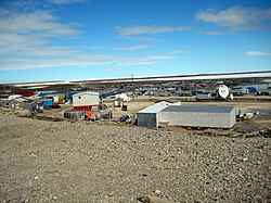
Igloolik
|
Igloolik ᐃᒡᓗᓕᒃ Iglulik |
|
|---|---|
| Hamlet | |

Igloolik
|
|
| Coordinates: 69°22′34″N 081°47′58″W / 69.37611°N 81.79944°WCoordinates: 69°22′34″N 081°47′58″W / 69.37611°N 81.79944°W | |
| Country | Canada |
| Territory | Nunavut |
| Region | Qikiqtaaluk Region |
| Electoral district | Aggu |
| Electoral district | Amittuq |
| Government | |
| • Mayor | Joseph Inooya |
| • MLA Aggu | Paul Quassa |
| • MLA Amittuq | George Qulaut |
| Area | |
| • Total | 102.87 km2 (39.72 sq mi) |
| Elevation | 53 m (174 ft) |
| Population (2013) | |
| • Total | 2,000 |
| • Density | 19/km2 (50/sq mi) |
| Time zone | EST (UTC−5) |
| • Summer (DST) | EDT (UTC−4) |
| Canadian Postal code | X0A 0L0 |
| Area code(s) | 867 |
Igloolik (Inuktitut Syllabics: ᐃᒡᓗᓕᒃ Inuit pronunciation: [iɣluː'liːk], sometimes spelled Iglulik) is an Inuit hamlet in Foxe Basin, Qikiqtaaluk Region in Nunavut, northern Canada. Because its location on Igloolik Island is close to Melville Peninsula, it is often mistakenly thought to be on the peninsula. The name "Igloolik" means "there is a house here". It derives from iglu, meaning house or building, and refers to the sod houses that were originally in the area, not to snow igloos. In Inuktitut The residents are called Iglulingmiut (the suffix miut means "people of"). The mayor of Igloolik is Joe Inooya.
Information about the area’s earliest inhabitants comes mainly from numerous archeological sites on the island; some dating back more than 4,000 years. First contact with Europeans came when British Navy ships HMS Fury and HMS Hecla, under the command of Captain William Edward Parry, wintered in Igloolik in 1822.
The island was visited in 1867 and 1868 by the American explorer Charles Francis Hall in his search for survivors of the lost Franklin Expedition. In 1913, Alfred Tremblay, a French-Canadian prospector with Captain Joseph Bernier’s expedition to Pond Inlet, extended his mineral exploration overland to Igloolik, and in 1921 a member of Knud Rasmussen's Fifth Thule Expedition visited the island.
...
Wikipedia

