Ichtegem
| Ichtegem | |||
|---|---|---|---|
| Municipality | |||
 |
|||
|
|||
| Location in Belgium | |||
| Coordinates: 51°06′N 03°00′E / 51.100°N 3.000°ECoordinates: 51°06′N 03°00′E / 51.100°N 3.000°E | |||
| Country | Belgium | ||
| Community | Flemish Community | ||
| Region | Flemish Region | ||
| Province | West Flanders | ||
| Arrondissement | Ostend | ||
| Government | |||
| • Mayor | Karl Bonny (CD&V) | ||
| • Governing party/ies | CD&V, BLAUW | ||
| Area | |||
| • Total | 45.33 km2 (17.50 sq mi) | ||
| Population (1 January 2016) | |||
| • Total | 13,945 | ||
| • Density | 310/km2 (800/sq mi) | ||
| Postal codes | 8480 | ||
| Area codes | 050, 051, 059 | ||
| Website | www.ichtegem.be | ||
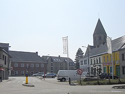
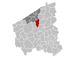
Ichtegem is a municipality located in the Belgian province of West Flanders 15 km southwest of Bruges. The municipality comprises the towns of Bekegem, Eernegem and Ichtegem proper. On January 1, 2006 Ichtegem had a total population of 13,423. The total area is 45.33 km² which gives a population density of 296 inhabitants per km². The current mayor is Karl Bonny.
In 2006, Ichtegem was declared the official Dorp van de Ronde (Town of the Tour) for the 90th annual road cycling race the Tour of Flanders.
Ichtegem:
Neighbouring villages:
...
Wikipedia


