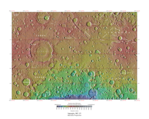
Iapygia quadrangle

Map of Iapygia quadrangle from Mars Orbiter Laser Altimeter (MOLA) data. The highest elevations are red and the lowest are blue. Terby (crater) contains many rock layers.
|
|
| Coordinates | 15°00′S 292°30′W / 15°S 292.5°WCoordinates: 15°00′S 292°30′W / 15°S 292.5°W |
|---|---|
The Iapygia quadrangle is one of a series of 30 quadrangle maps of Mars used by the United States Geological Survey (USGS) Astrogeology Research Program. The Iapygia quadrangle is also referred to as MC-21 (Mars Chart-21).
The Iapygia quadrangle covers the area from 270° to 315° west longitude and from 0° to 30° south latitude on Mars. Parts of the regions Tyrrhena Terra and Terra Sabaea are found in this quadrangle. The largest crater in this quadrangle is Huygens. Some interesting features in this quadrangle are dikes,. the many layers found in Terby Crater, and the presence of carbonates on the rim of Huygens Crater.
Near Huygens, especially just to the east, are a number of narrow ridges which appear to be the remnants of dikes, like the ones around Shiprock, New Mexico. The dikes were once under the surface, but have now been eroded. Dikes are magma-filled cracks that often carry lava to the surface. Dikes by definition cut across rock layers. Some dikes on earth are associated with mineral deposits. Discovering dikes on Mars means that perhaps future colonists will be able to mine needed minerals on Mars, instead of transporting them all the way from the Earth.
Some features look like dikes, but may be what has been called linear ridge networks. Ridges often appear as mostly straight segments that intersect in a lattice-like manner. They are hundreds of meters long, tens of meters high, and several meters wide. It is thought that impacts created fractures in the surface; these fractures later acted as channels for fluids. Fluids cemented the structures. With the passage of time, surrounding material was eroded away, thereby leaving hard ridges behind. Since the ridges occur in locations with clay, these formations could serve as a marker for clay which requires water for its formation. Water here could have supported life.
...
Wikipedia
