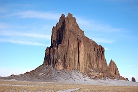
Shiprock
| Shiprock | |
|---|---|
| Tsé Bitʼaʼí | |

Shiprock
|
|
| Highest point | |
| Elevation | 7,177 ft (2,188 m) |
| Prominence | 1,583 ft (482 m) |
| Coordinates | 36°41′15″N 108°50′11″W / 36.68750°N 108.83639°WCoordinates: 36°41′15″N 108°50′11″W / 36.68750°N 108.83639°W |
| Geography | |
| Location | San Juan County, New Mexico, US |
| Topo map | USGS Ship Rock Quadrangle |
| Geology | |
| Age of rock | 27 million years |
| Mountain type | Volcanic breccia and minette |
| Designated | 1975 |
Shiprock (Navajo: Tsé Bitʼaʼí, "rock with wings" or "winged rock") is a monadnock rising nearly 1,583 feet (482.5 m) above the high-desert plain of the Navajo Nation in San Juan County, New Mexico, United States. Its peak elevation is 7,177 feet (2,187.5 m) above sea level. It lies about 10.75 miles (17.30 km) southwest of the town of Shiprock, which is named for the peak.
Governed by the Navajo Nation, the formation is in the Four Corners region and plays a significant role in Navajo religion, myth, and tradition. It is located in the center of the area occupied by the Ancient Pueblo People, a prehistoric Native American culture of the Southwest United States often referred to as the Anasazi. Shiprock is a point of interest for rock climbers and photographers and has been featured in several film productions and novels. It is the most prominent landmark in northwestern New Mexico.
The Navajo name for the peak, Tsé Bitʼaʼí, "rock with wings" or "winged rock", refers to the legend of the great bird that brought the Navajo from the north to their present lands. The name "Shiprock" or Shiprock Peak or Ship Rock derives from the peak's resemblance to an enormous 19th-century clipper ship. Americans first called the peak "The Needle", a name given to the topmost pinnacle by Captain J. F. McComb in 1860.United States Geological Survey maps indicate that the name "Ship Rock" dates from the 1870s.
...
Wikipedia

