Iōjima, Kagoshima
| Native name: 硫黄島, Iō-jima | |
|---|---|

Aerial view of the island. (February 2008)
|
|
| Geography | |
| Location | East China Sea |
| Coordinates | 30°47′27″N 130°17′46″E / 30.79083°N 130.29611°ECoordinates: 30°47′27″N 130°17′46″E / 30.79083°N 130.29611°E |
| Archipelago | Ōsumi Islands |
| Area | 11.65 km2 (4.50 sq mi) |
| Length | 5.5 km (3.42 mi) |
| Width | 4.0 km (2.49 mi) |
| Coastline | 14.5 km (9.01 mi) |
| Highest elevation | 703.7 m (2,308.7 ft) |
| Highest point | Iōdake |
| Administration | |
|
Japan
|
|
| Prefectures | Kagoshima Prefecture |
| District | Kagoshima District |
| Village | Mishima |
| Demographics | |
| Population | 121 (December 1, 2006) |
| Pop. density | 10.38 /km2 (26.88 /sq mi) |
Iōjima (硫黄島?), also known as Satsuma Iōjima (薩摩硫黄島?) or Tokara Iōjima (吐噶喇硫黄島?), is one of the Satsunan Islands, usually classed with the Ōsumi Islands, belonging to Kagoshima Prefecture, Japan. Along with Takeshima and Kuroshima, it makes up the three-island village of Mishima, Kagoshima Prefecture, Japan. The island, 11.65 km² in area, has a population of 142 persons.
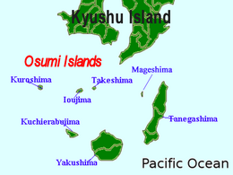
Iōjima is one of the Ōsumi islands, and is located 110 kilometres (59 nmi) south of Kagoshima. The island has an area of approximately 11.65 square kilometres (4.50 sq mi) with a length of 5.5 kilometres (3.4 mi) in length from east to west and 4.0 kilometres (2.5 mi) from north to south.
Iōjima is of volcanic origin, and is the northern edge of the Kikai Caldera, a stratovolcano rising from the ocean floor to 703.7 metres (2,309 ft) above sea level at its highest peak (Mount Iōdake). Kikai Caldera is ranked class A for volcanic activity. It is constantly erupting, emitting massive amounts of sulfur dioxide which causes damage to agricultural products. Hot springs high in iron concentration from the port bottom gush and due to contact with oxygen, the port waters change to a reddish-brown color. Due to the sulfur, the sea area around the island is yellow in color. This gave rise to the name "Sulfur Island" (Iōjima).
...
Wikipedia

