Hyndman Peak
| Hyndman Peak | |
|---|---|

Hyndman Peak
|
|
| Highest point | |
| Elevation | 12,009 ft (3,660 m) NAVD 88 |
| Prominence | 4,809 ft (1,466 m) |
| Coordinates | 43°44′58″N 114°07′52″W / 43.749432°N 114.131169°WCoordinates: 43°44′58″N 114°07′52″W / 43.749432°N 114.131169°W |
| Geography | |
| Parent range | Pioneer Mountains |
| Topo map | USGS Hyndman Peak |
| Climbing | |
| First ascent | 1889 |
| Easiest route | Simple Scrambling, class 2 |
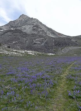
Hyndman Peak, at an elevation of 12,009 feet (3,660 m) above sea level, is the ninth highest peak in Idaho and the highest point in the Pioneer Mountains, Sawtooth National Forest, and Blaine County. Hyndman Peak is located on the border of Custer and Blaine counties. The towns of Hailey, Ketchum, and Sun Valley are west of the peak.
The first recorded ascent of Hyndman Peak was made in 1889 by W. T. Griswold and E. T. Perkins. The primary route to the summit is class 2, which along with its proximity to Sun Valley makes it a popular destination.
The trailhead to hike to Hydman Peak is located at the end of Sawtooth National Forest road 203 along Hyndman Creek. The primary route is approximately six miles (9.5 km) one way from the trailhead and traverses through Hyndman Basin, which is bordered by Hyndman, Old Hyndman, and Cobb Peaks. The route follows an unmaintained trail and ascends the Hyndman-Old Hyndman saddle before reaching the summit.
View from the summit
...
Wikipedia

