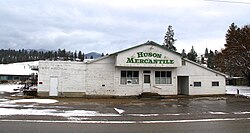
Huson, Montana
| Huson, Montana | |
|---|---|
| Census-designated place & Unincorporated community | |
 |
|
| Coordinates: 47°01′53″N 114°19′38″W / 47.03139°N 114.32722°WCoordinates: 47°01′53″N 114°19′38″W / 47.03139°N 114.32722°W | |
| Country | United States |
| State | Montana |
| County | Missoula |
| Area | |
| • Total | 0.737 sq mi (1.91 km2) |
| • Land | 0.736 sq mi (1.91 km2) |
| • Water | 0.001 sq mi (0.003 km2) |
| Elevation | 3,012 ft (918 m) |
| Population (2010) | |
| • Total | 210 |
| • Density | 280/sq mi (110/km2) |
| Time zone | Mountain (MST) (UTC-7) |
| • Summer (DST) | MDT (UTC-6) |
| ZIP code | 59846 |
| Area code(s) | 406 |
| GNIS feature ID | 785180 |
Huson is a census-designated place and unincorporated community in Missoula County, Montana, United States. Its population was 210 as of the 2010 census. The community is located along Interstate 90 19 miles (31 km) northwest of Missoula.
...
Wikipedia


