Hurricane Tanya (1995)
| Category 1 hurricane (SSHWS/NWS) | |

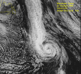
Hurricane Tanya near peak intensity in the Atlantic
|
|
| Formed | October 27, 1995 |
|---|---|
| Dissipated | November 3, 1995 |
| (Extratropical after November 1) | |
| Highest winds |
1-minute sustained: 85 mph (140 km/h) |
| Lowest pressure | 972 mbar (hPa); 28.7 inHg |
| Fatalities | 1 direct |
| Areas affected | Azores |
| Part of the 1995 Atlantic hurricane season | |
Hurricane Tanya was the first named storm to start with a "T" in the Atlantic since naming began in 1950, and the final storm of the very active 1995 Atlantic hurricane season. The twenty-first tropical cyclone, nineteenth named storm, and eleventh hurricane of the season, Tanya developed from a tropical wave while well north of the Lesser Antilles on October 26. The system headed northeastward and strengthened into Tropical Storm Tanya on October 27. Tanya meandered around the central Atlantic, and further intensified into a hurricane on October 29. Thereafter, Tanya tracked northeastward before curving to the east-northeast. After switching to an eastward direction, Tanya weakened to a tropical storm on November 1. Later that day, Tanya passed through the Azores as it was transitioning into an extratropical cyclone.
Throughout the Azores, the extratropical remnants of Tanya produced high winds. As a result, extensive property damage occurred, which included destroyed or damaged houses, and sunken boats; there were also reports of significant damage to agriculture. However, an exact damage toll figure in unknown. In addition, there was one fatality and several injuries.
The origins of Hurricane Tanya were from a tropical wave that moved off the western coast of Africa in the middle of October. The wave closely followed the path of Tropical Storm Sebastien and was unable to develop in the tropical Atlantic as it moved westward. The system did not begin to become organized until October 25 while south-southeast of Bermuda. However, the Dvorak technique was still unable to classify the system until October 26 as the low-cloud swirl became better organized while moving northward in the central Atlantic. That evening, a closed circulation had formed, and it was classified as Tropical Depression Twenty-One by the National Hurricane Center. On the morning of October 27, it strengthened into a tropical storm, becoming the 19th as well as the final named storm of the season. Operationally, it was not declared a tropical cyclone until that point, when it was immediately declared Tropical Storm Tanya.
Immediately after becoming a tropical storm, the movement of Tanya became hindered by a nearby upper-level low, and it quickly turned eastward before virtually stalling early on October 28. The upper-level low also influenced Tanya in giving it some subtropical characteristics, including a comma-shaped cloud band and maximum winds far from the center of the storm at the time. Despite that, the storm gradually strengthened as it remained over warm waters of about 81 °F (27 °C). That afternoon, it gained full tropical characteristics, as an eye featured was beginning to form in the central dense overcast. The eye became clearly defined, although it was small in size. Early on October 29, Tropical Storm Tanya was upgraded to a hurricane, the eleventh of the 1995 season, as it turned northward in response to the nearby low.
...
Wikipedia
