Hurden (Freienbach)
| Hurden | |
|---|---|
| Former municipality of Switzerland | |

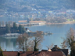
Seedamm and Hurden, as seen from Frohberg hill in Kempraten-Lenggis, the Capuchin monastery in Rapperswil to the left, Pfäffikon in the background
|
|
| Coordinates: 47°11.6′N 8°46.6′E / 47.1933°N 8.7767°ECoordinates: 47°11.6′N 8°46.6′E / 47.1933°N 8.7767°E | |
| Country | Switzerland |
| Canton | Schwyz |
| District | Höfe |
| Municipality | Freienbach |
| Area | |
| • Total | 1.31 km2 (0.51 sq mi) |
| Elevation | 408 m (1,339 ft) |
| Population (December 2008) | |
| • Total | 271 |
| • Density | 210/km2 (540/sq mi) |
| Postal code | 8640 |
| SFOS number | 1322 |
| Surrounded by | Altendorf, Switzerland, Pfäffikon, Rapperswil |
| Website |
www SFSO statistics |
Hurden is a village in the municipality of Freienbach in the canton of Schwyz in Switzerland. First mentioned in 1217, the name "de Hurden" was used for the peninsula and for the fish traps made of woven work, called "Hürden" or "Hurden", which were used by the locals.
The village of Hurden is located on an peninsula protruding from the southern shore of Lake Zürich at its narrowest point. The peninsula has its origin in the retreat of the Linth glacier at the end of the last glacial period when Lake Zürich was formed. This retreat left a moraine across the valley now occupied by Lake Zürich. The higher southern section of this moraine extends above the lake's water level and forms the peninsular, whilst the lower northern section forms a shallow section in the otherwise deep lake. Together these separate Lake Zürich into two parts, the larger lower lake to the north-west, and the smaller upper lake (Obersee) to the east.
The artificial Seedamm uses a combination of artificial causeways and bridges to cross the shallow water between the tip of the peninsular to Rapperswil on the northern shore of the lake, and carries both road and rail links. To the west of the Seedamm, there is a wooden bridge for pedestrians (Holzbrücke Rapperswil-Hurden), which was built in 2001 as a reconstruction of the first bridge between eastern and western lakesides. Since the construction of the Hurden ship canal, across the base of the peninsular, the natural peninsular has been transformed into an artificial island. The Sternenbrücke bridge carries both road and railway across the ship canal.
At Hurden also the Frauenwinkel protected area is situated. Its name origins from a donation by the emperor Otto I in 965 AD to the pin Unserer lieben Frau (Our Lady) to the Einsiedeln Abbey.
...
Wikipedia


