Hurdal
| Hurdal kommune | |||
|---|---|---|---|
| Municipality | |||
|
|||
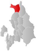
 Hurdal within Akershus |
|||
| Coordinates: 60°24′57″N 11°0′31″E / 60.41583°N 11.00861°ECoordinates: 60°24′57″N 11°0′31″E / 60.41583°N 11.00861°E | |||
| Country | Norway | ||
| County | Akershus | ||
| District | Romerike | ||
| Administrative centre | Hurdal | ||
| Government | |||
| • Mayor (2013) | Runar Bålsrud (V) | ||
| Area | |||
| • Total | 285 km2 (110 sq mi) | ||
| • Land | 261 km2 (101 sq mi) | ||
| Area rank | 284 in Norway | ||
| Population (2004) | |||
| • Total | 2,679 | ||
| • Rank | 292 in Norway | ||
| • Density | 10/km2 (30/sq mi) | ||
| • Change (10 years) | 5.4 % | ||
| Demonym(s) | Hurdaling or Hurdøling |
||
| Time zone | CET (UTC+1) | ||
| • Summer (DST) | CEST (UTC+2) | ||
| ISO 3166 code | NO-0239 | ||
| Official language form | Bokmål | ||
| Website | www |
||
|
|
|||
Hurdal is a municipality in Akershus county, Norway. It is part of the traditional region of Romerike. The administrative centre of the municipality is the village of Hurdal.
Hurdal is located about 70 kilometres (40 mi) north of Oslo, along the lake Hurdalsjøen. Fjellsjøkampen is the highest hill in Akershus. About 5 km north of the administrative centre, Hurdal, is the Hurdal Ski Centre.
The name (Old Norse: Urðardalr and Hurðardalr) is an old district name. (The name of the church site is Gjøing.) The first element is the genitive case of an old river name (later called Gjøingelva which means "Gjøing river"), probably Urð which means "stony river" (from urð which means "scree"). (The sideform Hurðardalr has an addition of a false /h/.) The last element is dalr meaning "valley" or "dale". Prior to 1918, the name was spelled "Hurdalen".
The coat-of-arms is from modern times. They were granted in 1988. The arms are green with a yellow-colored cone from a Norway Spruce tree (Picea abies).
The parish of Hurdalen was established as a municipality on 1 January 1838 (see formannskapsdistrikt). The new municipality of Feiring was separated from Hurdal on 1 January 1870.
...
Wikipedia


