Huntington, UT
| Huntington, Utah | |
|---|---|
| City | |

Looking northward along Huntington's Main Street
|
|
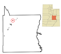
 Location in Emery County and the state of Utah.\ |
|
 Location of Utah in the United States |
|
| Coordinates: 39°19′45″N 110°57′57″W / 39.32917°N 110.96583°WCoordinates: 39°19′45″N 110°57′57″W / 39.32917°N 110.96583°W | |
| Country | United States |
| State | Utah |
| County | Emery |
| Founded | 1875 |
| Named for | William Huntington |
| Area | |
| • Total | 2.0 sq mi (5.3 km2) |
| • Land | 2.0 sq mi (5.3 km2) |
| • Water | 0.0 sq mi (0.0 km2) |
| Elevation | 5,787 ft (1,764 m) |
| Population (2010) | |
| • Total | 2,129 |
| • Density | 1,045/sq mi (403.6/km2) |
| Time zone | Mountain (MST) (UTC-7) |
| • Summer (DST) | MDT (UTC-6) |
| ZIP code | 84528 |
| Area code(s) | 435 |
| FIPS code | 49-36950 |
| GNIS feature ID | 1428946 |
Huntington is a town in Emery County, Utah, United States. The population was 2,129 at the 2010 census. It is the largest town in Emery County.
Huntington is named after Huntington Creek, and Huntington Creek was probably named for William, Oliver, and Dimick Huntington, brothers who led exploring parties into the region during the 1850s. The first settlers of European extraction in the area were four stockmen, Leander Lemmon, James McHadden, Bill Gentry, and Alfred Starr, who brought their herds to Huntington Creek in 1875.
In the fall of 1877, in response to the same call from The Church of Jesus Christ of Latter-day Saints that brought settlers to the other creeks in Castle Valley, a small group from Fairview, Utah, under the leadership of Elias Cox, established a dugout colony on the banks of Huntington Creek and began digging irrigation canals. The colony grew from 126 in 1880 to 738 in 1890 and 1,293 in 1910. A majority of the early settlers came from Sanpete Valley, which by the late 1870s had outgrown its irrigable land, and many belonged to three or four interrelated kinship groups, making for an abundance of cousins in the community.
In 1880 a mile-square townsite was surveyed on the Prickly Pear Flat, a bench south and west of the creek. The first structure erected on the new townsite was a 40-by-60-foot (12 by 18 m) log meetinghouse, which was completed in time for an all-night New Year's Eve party on 31 December 1880. Most of the townsite was without water until the completion of the Huntington Canal in 1882. Settlers drew town lots and built homes in town as they proved up on their homesteads. The first homes, some of which were still occupied until recent years, were typically of sawed log or plank construction or of adobe sheathed with lumber. The erection of a new LDS meetinghouse in 1896 inaugurated a twenty-year building boom that saw the completion of many brick homes, schools, and commercial buildings.
Huntington's early economic base was agriculture and stockraising. Alfalfa seed was an important cash crop around the start of the 20th century, and honey produced by local apiarist Christian Ottesen won first prize at the St. Louis World's Fair in 1903. For most of its history, however, Huntington has drawn its main income from coal mining. Small "wagon mines" in Huntington Canyon provided limited employment. The coal camp of Mohrland, 8 miles (13 km) to the north, active from about 1909 to 1938, was virtually an extension of Huntington, with many residents dividing the year between the mine and the farm. With the coming of better highways in the 1940s and 1950s, many miners commuted daily from Huntington to Hiawatha and other Carbon County mines.
...
Wikipedia
