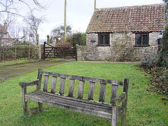
Hunstrete
| Hunstrete | |
|---|---|
 Hunstrete Green |
|
| Hunstrete shown within Somerset | |
| Population | approx. 100 |
| OS grid reference | ST647624 |
| Unitary authority | |
| Ceremonial county | |
| Region | |
| Country | England |
| Sovereign state | United Kingdom |
| Post town | BRISTOL |
| Postcode district | BS40 |
| Dialling code | 01761 |
| Police | Avon and Somerset |
| Fire | Avon |
| Ambulance | South Western |
| EU Parliament | South West England |
| UK Parliament | |
Hunstrete (grid reference ST625643) is a small village on the River Chew in the Chew Valley, Bath and North East Somerset, England. It falls within the civil parish of Marksbury and is 8 miles from Bristol, and Bath, and 5 miles from Keynsham.
The origin of the name Hunstrete is unclear. One explanation is that it means 'The hundred road' from the Old English hund and street. Other possible derivations are the personal name hund and Old English steort meaning a projecting piece of land or hund meaning hound or dog relating to the place where they were kept.
Although occupation during the Iron Age is possible the earliest evidence are Roman coins from the emperor Carausius, and continuous occupation during the Saxon period may have been connected with the nearby Wansdyke. A charter of 936 suggests the land was given to a thegn by the name of Ethelelm by Æthelstan. The manor was granted to Glastonbury Abbey who held it until the dissolution of the monasteries in 1539 when it was forfeit to the crown and granted to Richard Watkins. At the beginning of the 17th century it passed to the family of Sir John Popham, whose descendants sold off portions of land in the intervening years but owned Hunstrete House until 1977.
...
Wikipedia

